The government of Suffolk County has been a leader in creating environmental and conservation initiatives and legislation over the last half century.1 Many were the first of their kind within New York State and even the country. Why is this? Economics? Limited natural resources? Personnel? And when did this begin? The county’s legacy of protecting natural resources and the environment continues to this day. The primary areas for the county’s actions centered on preservation of water quantity and quality (surface and drinking), management of sewage and solid waste, and maintenance of agriculture and open space.

Figure 1: Elevation map of Suffolk County. County online maps.
Setting the Local and National Stages for Environmental Protection
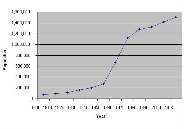
Suffolk County, the eastern two thirds of Long Island, was established in 1683 and was one of the original 12 counties of what would become New York State. The county contains some of New York’s oldest English settlements including Gardiner’s Island (1639), Southampton (1640), Southold (1640), and East Hampton (1648).2 After nearly 300 years of gradual growth, in the 1960s it became the fastest growing county in New York State3 and in 2004 was ranked the 21st most populous county in the United States.4 As population grew5 (Figure 2), the county shifted from multiple acre farms to relatively high-density residential development (this is a process that had been underway since the 1920s).6 This was especially true in the western part of the county and is reflected in today’s uneven population distribution. In 2005, western Suffolk County had a population density of 4.4 persons per acre compared to eastern Suffolk County’s population density of 0.6 persons per acre.7

Figure 2: Population growth in Suffolk County, 1900-2008.
In 1960, with adoption of the Suffolk County Charter, governance switched from a Board of Town Supervisors (ten total) to include an elected county executive. Subsequently, the standard for the county’s environmental ethic and in many ways its blueprint was the 1964 publication, A Plan for Open-space in Suffolk County. The plan justified the need for open space: historically, sociologically, geographically, and economically.8 It also suggested the means by which to acquire and assure that such space would exist into the future. Initially, there was resistance to such progressive ideas but by the early 1970s, the American public, including Suffolk County residents, had begun to show a growing concern for the environment. This was reflected in the fact that approximately 20 million Americans took part in the first annual Earth Day, held on April 22, 1970. This important day marked the formalization of the national environmental movement. And Suffolk County was at the forefront.
President Richard Nixon and the U. S. Congress reacted to the national public sway toward environmental protection by creating several federal environmental organizations including the Environmental Protection Agency (EPA) and the National Oceanic and Atmospheric Administration (NOAA). In addition, Nixon signed a spate of environmental legislation including: the National Environmental Policy Act (1969), the Council on Environmental Quality (1969), Marine Mammal Protection Act (1972), the Clean Water Act Amendments (1972), the Marine Protection, Research and Sanctuaries Act (1972), the Coastal Zone Management Act (1972) and the Endangered Species Act (1973).
Concurrently, Suffolk County amended its county charter in 1970 with the passage of the Environmental Bill of Rights (Article 1). This was groundbreaking county legislation modeled after the National Environmental Policy Act (including the creation of the Council on Environmental Quality). It made environmental conservation an objective for the county and recognized the need for pollution control, management of air, water, solid waste, and preservation of open space, and agricultural lands. It also included a mandate for historical preservation.9
Water and Waste Management: Protecting a Limited Resource from Use by New York City
Protecting the availability of fresh water was a primary concern that had driven earlier conservation efforts in Suffolk County. New York City Mayor William Gaynor, in 1911, contemplated drawing upon Suffolk’s water supply. While living at his Deepwells Estate (now a county park) in St. James, he toured areas in the county that might supply Brooklyn and the rest of the city with water.10 (Figure 3) The city was perched like a vulture waiting to pounce on the county’s water if the need arose and the opportunity presented itself.11 Before the Environmental Bill of Rights, as early as the 1930s, Suffolk residents recognized the issue of limited water supply on the island and began protecting it primarily from the demands of heavily populated and water-greedy New York City.

Figure 3: New York Times article about Mayor Gaynor’s survey of Suffolk County water sources, 1911.
In 1934, the Suffolk County Board of Supervisors proposed selling water to New York City. 12 The public protested. A local stockbroker and Republican political boss, W. Kingsland Macy, led the fight against the proposal in order to protect the ground water of Long Island.13 The proposal was defeated. Also in 1934, the Water Power and Control Commission of the State of New York was created, establishing a state water control department.14
These two events led Macy to push for county water control and in 1937 the Suffolk County Water Authority was established with Macy as chairman.15 That same year, the Suffolk County Water Authority successfully helped Nassau County prevent New York City from claiming water under its lands. The advocacy temporarily stopped the drilling of wells in Nassau County and sent a strong message that Suffolk County would back the defense of the island’s groundwater supply for residents in its neighboring county. County Supervisor Edgar A. Sharp from the Town of Brookhaven said it was of utmost importance to protect Suffolk County water from being taken by New York City and because Nassau and Suffolk Counties depended on the same aquifer, protection extended to Nassau.
New York City tried to capture additional Long Island water again in 1940, this time proposing the drilling of numerous new wells in Nassau and Suffolk Counties (a total of seven in Suffolk) with a combined pumping volume of 50 million gallons per day, exclusively for the city.16 The Suffolk County Water Authority led the fight against the city, and their efforts finally defeated the proposal in 1942. The Water Power and Control Commission declared “unappropriated ground water” was needed for growing Nassau and Suffolk Counties and that New York City had other sources far less limited than the Long Island aquifer. The commission also suggested that water works be owned and operated by counties and not subject to state control and New York City’s demands.17
Controlling Sewage and Landfill Pollution, Recognizing Value of Coastal Wetlands
Water as a valuable resource gradually extended from quantity of ground water for drinking to concerns regarding pollution from sewage and landfilled municipal solid waste (MSW). Preserving tidal and surface waters was also considered important. In 1944, two projects were initiated to protect ground water for purposes other than preventing use by New York City. The first was the initiation of an investigation of Suffolk County ground water by the U.S. Geological Survey (USGS).18 This multi-year study began the full mapping and recording of the dimensions and condition of the Long Island aquifer. The project continued through 1950. The second was the development of Suffolk’s first County Sewerage Plan19, based on the concern that Suffolk County’s multiple individual cesspools were unregulated and potentially polluting surface and ground waters. It would take another 15 years to establish the Suffolk County Sewer Agency in 1965 and the beginning of serious efforts to renovate and regulate sewage throughout. This first sewerage plan was an early recognition of the mounting problems presented by accumulated waste and water pollution resulting from anticipated population growth.
In 1945, the Water Authority informed the Board of Supervisors of the dangers of allowing Nassau County to pump ground water in Suffolk County. New York City had already pumped Kings and Queens Counties nearly dry. From 1931-1946, some 70-90 million gallons of water per day were pumped for public use from Brooklyn, Queens, and Nassau County at the western fringe of the Long Island aquifer.20 Nassau County was given permission by then Governor Thomas Dewey to pump outside of its lands, namely in Suffolk County.21
The above situation led to the 1946 passage of legislation proposed by newly elected State Senator Macy that removed the power of any municipality to enter Suffolk County to mine water and acquire sites for garbage and refuse disposal as well as sewer facilities.22 In essence, Suffolk County legislatively shut its borders to keep its water resources safe from outside use and potential pollution. Four years after his initial suggestion, Macy had also successfully arranged for a county owned and operated water works. Now known as the Suffolk County Water Authority, it has gradually acquired many private water companies in the county and assures that county residents have high quality drinking water.
A quote from the 1949 Proceedings of the Suffolk County Board of Supervisors sums up the prevailing attitude toward water protection at the time:
Whereas, in addition to the need for pure drinking water and for general sanitary purposes in a community growing residentially and commercially, this County, for its annual 45 million dollar agricultural products and its annual two and one-half million dollars of fish and shellfish interests requires irrigation for protection against drought and the brackish water resulting from the co-mingling of the fresh with the salt, now, therefore, be it resolved, that this Board go on record that the guarding of the County’s fresh water resources be its foremost duty and pledges itself to do all within its power to support the Suffolk County Water Authority to that end.23
Almost coincidentally, the U. S. government passed the Federal Water Pollution Control Act of 1948, commonly known as the Clean Water Act. For the first time, water pollution became a nationally regulated issue.24 During 1956-1957, independent water resource studies were conducted in Nassau County and Suffolk County. Colonel Thomas H. Wiggen undertook the Suffolk County study in order to approximate the recharge volume based on rainfall and runoff. This was the first suggestion of potentially using recharge basins to re-supply the aquifer in Suffolk County (Nassau County began using recharge basins as early as 1935).25
The National Geographic magazine featured a 1951 article on Long Island as “one of the fastest growing regions of the United States.” In the years leading up to the article, the “population of (New York’s) so-called rural counties had increased more rapidly than New York City or the nation as a whole.”26 Not only was population growth putting pressure on the water supply and its cleanliness, but being one of the “so-called rural” counties, Suffolk County had an extremely successful agricultural industry in duck farming which was also causing water quality concerns.27
Duck farms were typically located on the shores of streams and duck waste consequently washed directly into the natural water systems. In the 1950s, marine pollution from the economically valuable duck farms brought a team of Woods Hole Oceanographic Institution oceanographers (sponsored by the Towns of Brookhaven and Islip) to examine the waters of Moriches Bay and Great South Bay.28 The scientists declared these waters to be “highly contaminated” and in need of restoration. The nearly decade-long study of these waters became a case study for anthropogenic pollution presented at the President’s U. S. Environmental Pollution Panel in 1965. Town resolutions regarding public health concerns due to duck waste pollution were passed in 1963 and in the same year the Suffolk County Department of Health began investigating duck waste treatment measures. Dredging for increased tidal flow and physical removal of waste by the county provided temporary reduction of duck waste pollution but did not prevent the continued deterioration of the water quality. This case began the discussion for the need of pollution reduction at the source, duck farms in this case, rather than attempted removal once in the system. Tightening pollution regulations, increasing population, and escalating value of real estate all contributed to the duck farming industry leaving Long Island by the mid-1980s.29
County Charter Approval, County Legislative Leadership Begins
In 1960, the year the county charter was approved, Suffolk County was rated the fastest growing county in the nation. Previously, Nassau County had held this title.30 The demand on Long Island’s limited water supply and the need to protect it continued to grow. With the election of engineer H. Lee Dennison as County Executive and appointment of landscape architect Lee Koppelman as Director of Planning, a myriad of trailblazing studies were conducted to better evaluate the water, sewage and waste issues within Suffolk. Both men had visions of establishing new public works in the county but during the early 1960s the public response to governmental regulation of land and water use met with initial resistance. Despite this negative reaction, the new county government kept pushing for more studies and management, and by the late 1960s public opinion toward conservation became more supportive, leading to a booming period of county environmental legislation in the 1970s.
A Suffolk County study examined the need and feasibility of constructing public sewers in 1961. At the time there were some 200,000 cesspool in the county leading to multiple ground and surface water polluting episodes.31 It was reported that 97 percent of the people living in Suffolk County were not served with public sewers and it would cost “$3000 per house to sewer – almost $400 million.”32 Housing lots at the time in much of Suffolk County were based on high density zoning from the 1920s. The study found that in order to have a properly denitrified cesspool, development needed to be limited to one or two individual lots per acre.
An initial proposition to establish a public sewage system was proposed in 1963 but garnered no public support. In response, a Citizen’s Committee for Public Sewers chaired by the head of the Suffolk County Health Department was created and it presented a convincing argument that cesspool waste was infiltrating drinking water.33 The approval of public sewerage led to the establishment of the county Sewer Agency in 1965. It was responsible for sewage collection, conveyance, treatment and disposal as well as the monitoring of associated water resources within and without Suffolk County. New York State Governor Rockefeller recognized this problem of rapidly growing counties needing public sewerage and in 1965 proposed a $1 billion bond issue to construct domestic sewers in New York State with additional support from the Federal Government.34 The county acquired as its first sewage treatment plant the already constructed 1.5 million gallon per day facility in Port Jefferson in 1970.35 The Bergen Point plant was the first that the county actually built and it went on line in 1981.36
The county’s need to preserve the quantity and quality of its drinking water supply was reinforced by the drought that affected much of the United States Eastern Seaboard, from 1963-1966. Annual rainfall averaged over those years as measured at JFK International Airport was about 20 percent less than the long-term mean at the time.37 Long Island’s water supply remained sufficient, but the groundwater table dropped and New York City was looking to supplement its supply as water levels in its reservoirs declined.
Around the same time, the county-level Open Space Plan of 1964 identified the environmental and economic value of wetlands. Before this, wetlands, previously referred to as swamps, were considered most useful when filled, dredged or being utilized to provide construction aggregates of sand and gravel. Yet, the shellfish industry relied upon these tidal wetlands for high returns ($5,000-$60,000 capitalized value per acre) so the need to preserve these highly productive areas as a perpetual source of revenue and recreational benefits became a focus.38 In 1965, Dr. Mark A. Frey, president of Unified Research, Inc., spoke to the Nassau-Suffolk Regional Planning Board (NSRPB) about the development of oceanographic activities on Long Island and the new federal grant programs to stimulate research in the field. This led to the establishment of the Oceanographic Committee. The Committee began a study on the status and potential of Long Island’s marine environment. Initially the study focused on economic value, tourism, and commercial and sport fishing, but the Committee came to the conclusion that to maintain economic and commercial value, it was necessary to better understand the effect of population expansion on the health of marine systems as a whole.39
At the time, no U.S. university-based oceanographic laboratory was specifically studying the coastal zone. The Oceanographic Committee pushed for the creation of the Marine Sciences Research Center (MSRC) in order to establish a coastal studies center, the first such in the U.S., emphasizing both research and education. In 1965, Suffolk County convinced the Board of Trustees of the State University of New York to create MSRC as part of Stony Brook University (SBU). The center prospered and has been involved in many of Long Island’s regional environmental issues. Today, it exists as the School of Marine and Atmospheric Sciences.
The work of the Committee also led to the establishment of the Nassau-Suffolk Regional Marine Resources Council (RMRC) that existed from 1967 to 1983 and was composed of representative marine stakeholders from the private sector with advisors from governmental agencies. The task of RMRC was to conduct studies to formulate a comprehensive plan for the management of the marine environment. The council identified 17 marine related problems, many the same as today, and initiated efforts to preserve wetlands, reduce the impact of wastewater disposal, prevent barrier beach erosion and address various sources of marine pollution.40
Also in the 1960s, the confluence of a fish kill in a lake in Yaphank and concerns that birds and animals of the marine environment were being adversely impacted caused Victor Yannacone, a lawyer, and Dr. Charles Wurster, a SBU environmental scientist, to work together to legally stop the Suffolk County Mosquito Extermination Commission from using DDT to control mosquitoes. Ultimately, the courts did not side with the plaintiffs. However, the Suffolk County Board of Supervisors concurred about the detrimental effects of using DDT and in 1966 supported a ban of its use in the county, the first such ban in the country. New York State followed Suffolk’s lead in 1970, as did the federal government in 1972.41 Yannacone and Wurster along with Dennis Puleston and Art Cooley used the Suffolk County experience as a springboard to found the Environmental Defense Fund in 1967, which today is a national organization with an expanding international impact.
National Movement toward Environmental Protection, Suffolk County Leadership
In 1968, the Suffolk County Charter Review Committee proposed the Environmental Bill of Rights, which was drafted by Irving Like, Esq. This was unique for county legislation. The law to amend the Suffolk County Charter and include this Bill of Rights was adopted on August 11, 1970 and was officially enacted in January of 1971.42 Specific reference was made for the need to protect wetlands and shorelines, abate water pollution, conserve and regulate water resources, purchase development rights of agricultural lands, and acquire land and waters for county nature preserves.
The 1970s was a landmark decade for environmental preservation and passage of regulations both nationally and locally. In the same year as the approval of the Suffolk County Environmental Bill of Rights, the Bi-County Comprehensive Land Use Plan of the Nassau-Suffolk Regional Planning Board was published. This was a result of a five-year study funded by the New York State Department of Health to address waste disposal, water supply, and installation of water treatment systems. It weighed the advantages and disadvantages of recharging sewage effluent to groundwater supplies instead of discharging it into the ocean. The results found recharging the effluent would help maintain surface water levels but significantly advanced water treatment procedures would be needed to satisfactorily clean the effluent before recharging was possible. This examination concluded 13 years after the Wiggen report of 1957 first suggested recharging unused water run-off as a way to replace groundwater resources in Suffolk County. Recharging would reduce the drawdown of the water table that resulted from ocean outfalls. These investigations put Suffolk County in an excellent position to be one of the early recipients of grant funds associated with the Federal Water Pollution Control Act Amendments of 1972.43
An influential piece of legislation passed by the Suffolk County Legislature was the 1971 Detergents Ban, a first in the nation.44 The replacement of naturally-derived soaps with synthetic detergents led to pollution of the aquifer supplying Long Island’s drinking water. The synthetic detergents contained surface active agents (alkyl benzene sulfonates, alcohol sulfates and methylene blue active substances) that did not degrade sufficiently and waste water containing these pollutants was then transferred directly to the underground water table through individual septic systems.45 These pollutants then resurfaced as soap scum on freshwater bodies, indicating contamination of drinking water supplies. The importance of the water supply and the problem with wastewater management at the time were well stated in the legislative findings of the law:
Groundwaters are the only existing source of water supply in Suffolk County. The major source of water supply for homes, commercial establishments and some public water supply wells is that underground source known as the Glacial Aquifer. Beneath that is another source known as the Magothy stratum. Because of the lack of public sewerage facilities, the continuing population growth, the occurrence of the water table within relatively shallow depths, and because of the very slow movements of groundwater to discharge to salty water, groundwaters are vulnerable to contamination. It is vital to the health, well-being and welfare of present and future inhabitants of Suffolk County that these sources be protected against contamination and pollution.46
The law banned the sale of any detergents containing the above named surface agents in Suffolk County, except when needed for specific disinfecting purposes. This eventually led to an industry-wide change in the chemical composition of detergents. Subsequently, the county ban was removed in 1981.
Federal Action Spurs Local Action
Section 208 of the Federal Water Pollution Control Act Amendments of 1972 required that all potable and swimmable waters in the country must achieve specific national water quality standards by 1980. Many Republicans saw this as an imposition on the private sector. Despite being a Republican-dominated county, the Suffolk legislature responded to this challenge by increasing its efforts to improve water quality and management from numerous angles.47 With a history of concern for the cleanliness of drinkable water already established, Suffolk County along with Nassau County undertook one of the first comprehensive studies based on Section 208 requirements that resulted in the publication of a plan to manage water at the county level.
The Long Island Comprehensive Waste Treatment Management Plan48 was the culmination of the 208 Study and examined many aspects of surface and groundwater pollution including the need for regional management.49 Eight hydrogeologic zones (Figure 4), with differing recharge characteristics in Nassau and Suffolk Counties, were identified. This study also showed that one acre zoning was needed to keep groundwater impacts acceptable and yet allow development to proceed. In addition, pathogenic contamination from a variety of sources was examined.

Figure 4: Hydrogeologic zone map, Suffolk County. County online maps.
In part, as a consequence of the 208 Study and based on a 1975 petition from the Environmental Defense Fund, the Long Island aquifer was specified by the U.S. EPA in 1978 as one of the first “sole source aquifers” in the country50 and the first in New York State.51 It is recognized under the Safe Drinking Water Act of 1974 as a principal source for public drinking water, which if contaminated, could become a public health hazard. Greater federal recognition and protection came with the passing of the New York State Sole Source Aquifer Bill in 1987.52
Concern about unlined landfills polluting the Long Island aquifer dates to at least the 1970s. But there certainly was not consensus within the county of what action should be taken to lessen their impacts. However, with the recommendation by the New York State Commission on the Water Resource Needs of Long Island53, the state legislature passed (with full support of the Long Island delegation54) the Long Island Landfill Law of 1983 (NYS Environmental Conservation Law, Article 27-0704). The state law specifically banning use of landfills in the aquifer’s deep recharge areas reflected Suffolk County’s local concerns. The law required that all such landfills must be closed by December 1990.
The resulting reports for the Section 208 studies directly led to many significant water resource management laws for Suffolk County and greater Long Island. They included:
- The Long Island Segment of the Nationwide Urban Run-Off Program.55 This was one of the first 19 areas across the country to be selected to study the consequences of stormwater runoff on water quality.56
- The Nonpoint Source Management Handbook (1984) – a first for county management of nonpoint pollution sources.57
- The Special Groundwater Protection Area (SGPA) Project Report58 – introduced SGPAs based on environmentally sensitive hydrogeologic zones from the original report and specified the Pine Barrens as a valuable area for groundwater recharge.
- The Suffolk County Drinking Water Protection Program, which established “legal buying areas” as part of a comprehensive acquisition plan for protection of ground water in SPGAs including the Pine Barrens Wilderness Area and Water Protection Preserve.59
- The Long Island Comprehensive Special Groundwater Protection Area Plan (1992) provided integration and regulation of nine proposed SGPAs in Nassau and Suffolk Counties. All SGPAs are also designated as Critical Environmental Areas (CEA) defined as natural areas that are ecologically, geologically or hydrologically sensitive. These then became pursuant to SEQRA, the State Environmental Quality Review Act.60
- The Extension of the Drinking Water Protection Plan (1998) – approved acquisition of wetlands, watersheds and several regional estuary programs deemed environmentally sensitive to maintaining water quality that were not previously included in the 1987 Plan.61
Reining in Litter, Plastics, and Cesspool and Gasoline Additives
In the 1980s, the recommended switch to waste management centers followed by the mandated closure of landfills on deep-flow recharge sites by 1990, created a space crisis for waste disposal. Landfill space was diminishing and transport of waste off the island was becoming more expensive. The Suffolk County Legislature decided to approach the problem by attempting to reduce non-biodegradable waste destined for landfills. This approach was the genesis for both the 1982 “Bottle Bill” and the 1988 “Plastics” Law.
In 1981, Suffolk County became the first county in New York State to implement a refundable bottle deposit program by passing a law proposed by Legislator Patrick Halpin.62 This program supported the recycling of used beverage containers and set the framework for Halpin, after being elected to the State Assembly the very next year, to introduce a statewide Returnable Container Deposit Act (commonly known as the Bottle Bill) that was passed into law. The objective was to reduce litter, ease the burden of solid waste facilities, and encourage recycling practices. Until the year 2009, this act only applied to carbonated beverages including soft drinks, beer, and malt beverages.
The New York State Landfill Law and the increased concern for groundwater protection, in part, drove the Suffolk County Plastics Law of 1988 (properly titled “A Local Law to Simplify Solid Waste Management by Requiring Certain Uniform Packaging Practices in the County of Suffolk”). It was the first law in the country attempting to reduce the increasing amounts of plastic waste entering the waste stream.63 The waste of primary concern was non-biodegradable plastic packaging, particularly that composed of polystyrene or polyvinyl chloride. These compounds were found to be especially prevalent in discarded packaging from “retail food establishments” which constituted a large quantity of Suffolk County’s waste stream and, when incinerated, released potentially harmful toxins.64 The combined environmental impact of rapidly filling landfills encroaching on groundwater-sensitive recharge areas and the introduction of toxic byproducts prompted the banned use of packaging containing the above compounds. They were to be supplanted by biodegradable options, such as paper or cellulose-based materials. There were exemptions to the ban including plastic wrap covering raw foods, packaging used at hospitals and nursing homes, and paper or cellulose-based packaging with polyethylene plastic coating on one side. Overall the law introduced a new attempt to reduce refuse and protect environmentally sensitive groundwater recharge areas. This law also mentioned the noticeable increase in use of plastic shopping bags and their non-biodegradable nature. It prohibited their use at the point of sale at retail food establishments.
The plastic ban act was a well-intentioned law, but was flawed in a number of respects. The law was weakened through exemptions, would not have achieved its goals based on waste counts and existence of other laws, was difficult to understand and enforce, and in some respects was inequitable.65 Nearly two decades later, in another effort to reduce plastic waste, the Suffolk County Legislature passed Local Law 34 of 2007 to “Establish an At-Store Recycling Program for Plastic Bags.”66 This was the first countywide law in New York State requiring such recycling in grocery stores with the purpose of reducing the number of bags proliferating in the environment. In 2009, the legislature discussed expanding this law to include paper bags and retail stores in general — not just grocery stores. It has been put on the back burner for now.
The county was also the first in New York State to ban organic cesspool additives used to clean or unclog sewage lines. This Local Law (12-1980) was adopted to protect ground water.67
A more recent Suffolk County Legislative first protecting the county’s water supplies came with the 2000 Methyl Tertiary-Butyl Ether (MTBE) Ban in gasoline. MTBE is a gasoline additive used to oxygenate fuel to make it burn more efficiently and cleanly. Groundwater quality studies found the additive in local water supplies with over 100 drinking water wells contaminated.68 Concern about the health effects of the chemical led to studies that showed MTBE to be a potential carcinogen. A ban on the use of MTBE in gasoline sold in Suffolk County was passed in 2000 as Local Law 1139-2000. Suffolk County’s concern led to a state level investigation and the ban became New York State law in 2004. By 2006, the ban extended to numerous states leading to a widespread disuse and replacement of MTBE in gasoline.69 In 2003, Suffolk County led a lawsuit against the oil companies selling the MTBE additive fuel, requiring them to pay for the cleanup of the contaminated wells. In 2008, an agreement was finally reached, with the oil companies paying $73.4 million to Suffolk County alone (17 states were involved) for clean up of existing and future sites.70
Agricultural Lands and Open Space
As Long Island became a destination for industries and families looking for breathing room outside of New York City, a conflict between land development and preservation of open spaces for parks, beaches and preserved natural areas began to grow. With the expansion of bridges, expressways and parkways during the 1920s and 1930s and the development of weekend get-away communities such as Mastic Park, formerly inaccessible areas of Long Island began to become a highly attractive escape from the big city.71
Robert Moses: the Curtain Opens on the Battle between Development and Open Space
Historically, Long Island was desirable for its open, arable land and productive coastlines. From the earliest settlements through the 1920s, residents made their living from the land and sea and benefited from keeping space available for farming. But Robert Moses was to change much of that, beginning with his discovery and researching of “water supply properties” in Nassau County.72 These undeveloped lands along stream corridors were owned by the City of Brooklyn dating back to the late 1800s and were acquired to be sites of potable water reservoirs, originally for Brooklyn and then New York City drinking water if ever needed.73 Moses saw them as city-owned properties that could serve as transportation corridors to Fire Island or other destinations for outsiders from New York City. They were there for his taking.
In 1922, Governor Alfred Smith had Robert Moses serve as an observer for reform organizations looking to create parks including recreational destinations outside of crowded urban areas for newly mobile city dwellers with automobiles.74 Moses immediately became intrigued by the recreational possibilities of Long Island and in 1924 was appointed President of the Long Island State Park Commission. With his new position, Moses initiated the creation of Jones Beach State Park. His connecting roadways projects included the Southern and Wantagh Parkways. The beach and the parkways all opened in 1929.75
Jones Beach State Park is one of the most ambitious and impressive public beaches in the entire country. But going well beyond Jones Beach, during his tenure from 1924 to 1968, Moses created a total of forty thousand acres of parks on Long Island including Sunken Meadow, Hither Hills, Montauk Point, and Belmont Lake in Suffolk County.76 Yet, along with the protection and preservation of these open spaces for public recreation came the building of roads to access them. Moses was responsible for creating an extensive network of bridges, expressways and parkways across New York City and Long Island to connect his park projects to city dwellers. For future works, he often uncompromisingly wielded eminent domain over private properties, mainly farms as opposed to wealthy landowners’ properties, to create his roadways. His paved Northern and Southern Parkways provided throughways for automobile commuters to visit the natural beauty of Long Island end-to-end, by displacing many small farmers and reducing usage of public commuter systems like the Long Island Rail Road. By the 1930s, he had, in essence, made an easy, car-friendly pathway to Long Island’s future suburban sprawl.77
The National Geographic Magazine (1951) glorified the development boom and population growth on Long Island.78 Many developers saw the potential for new, clean spaces for industry—smoke and noise free as compared to New York City — and plenty of room on the former estate and farmland for employees to live nearby in new suburbs. As stated in the article:
Between Long Island and New York’s towers, hundreds of trainloads of white-collar commuters daily ebb and flow. Increasing thousands call the island home, and many now earn a living in its hundreds of new industries…multiple housing developments mushroom. Along with them sprout streamlined factories and modern shopping centers, transport and recreational facilities. Much of the activity burgeons where it seems only yesterday myriad acres of potatoes grew.79
With the returning GIs looking to start families in areas of growth with employment opportunities, “rural” Nassau and Suffolk Counties’ former potato fields and other farmlands became the perfect areas to experiment with model mass home production. Levittown in Nassau County was one such example, building 10,101 new homes by December of 1949 and increasing that to 15,046 homes by March of 1951.80 The demand for these homes was so high that there was often a waiting list several years long at the peak of development. This growth continued to skyrocket into the 1960s. From 1950 to 1960 western Suffolk County showed a 161 percent growth while eastern Suffolk County grew by an average of 40 percent.81 The countywide population forecast for 1970 relative to 1960 estimated a growth of 64 percent with an additional growing summer or tourist population of 150,000 residents.
An Early Vision for Open Space
People and Parks82, the first plan addressing open space, noted the deficiency of approximately 4,000 acres of municipal parks in the county that was growing so rapidly. It also referred to agricultural land and undeveloped land collectively as open space. John Wickham, a local engineer and farmer who later served on the Suffolk County Planning Board, protested this linkage pointing out that agricultural land was definitely not undeveloped and had important economic and cultural value.83 Thereafter, agricultural acreage and “open” space were treated separately both legislatively and programmatically. Also in 1960, the American Society of Landscape Architects held a forum in New York City focusing on parks and open space including government’s role in acquiring and managing such properties.84 Suffolk County recognized that it must move aggressively to protect its farms and open space in order to foster its own sustainability and to protect its lands from development pressures already experienced and anticipated from New York City.
Farmland
Going back to the 1950s, there were about 123,350 acres of farmland in Suffolk County, but by 1972, some 45 percent of that farmland had been lost leaving only 68,000 acres; farming had all but disappeared in Nassau County. John V. N. Klein, the Suffolk County Executive at the time, pointed out that increased property taxes, onerous inheritance taxes, and increased value of land were the causes precipitating the disappearance of agricultural lands. Farms were particularly attractive to developers because of limited ownership for large land parcels that were generally level, cleared, and well drained.85 Recognizing that the farms of the county were in peril, the County Executive instituted a Purchase of Development Rights (PDR) program for farmland in 1974. In 2007, it was the oldest such program in the United States and since the program continues today, it is still the oldest.86 Suffolk County made it clear to the rest of the country that the nation’s agricultural heritage was in jeopardy unless protective measures were put in place.
Perhaps one of the most significant pieces of county farmland legislation was the local law known as “The Right to Farm,” which was passed in 1982. The law protects farms from encroaching developmental pressures that find farming practices objectionable.87 Subsequent to the PDR program for farms, the county adopted other strategies to preserve farming. These include creating means to raise revenue for PDRs such as installment purchases, bargain sales, and estate planning (farm family receives tax benefits), donation of conservation easement.88
In 2005, there were about 32,560 acres left in agriculture in the county. Some 15,000 acres of farmland have been permanently preserved through county, town, and private programs. This is 50 percent of the county’s 1972 goal of preserving 30,000 acres.89
Early Acquisitions
In 1960, State Park Commissioner Moses authored a New York State bond referendum of $75 million to obtain parkland. An allotment of $25 million was to be distributed to the 57 counties in the state.90 Suffolk County had knowledge about the bond before its public announcement due to the close friendship County Executive Dennison had with Moses. This insider information allowed Suffolk County and Planning Director Koppelman to present a plan for acquisition ahead of other counties thus delivering $3 million of the $25 million to Suffolk County—a disproportionate 12.5 percent of the total for the state.91 In essence, this infusion launched Suffolk County’s open space preservation plan with the purchase of tracts of land in the critical Peconic River watershed river valley.92
The Groundbreaking Plan for Open Space
…the retention or acquisition of lands for the preservation of natural areas, parks, farms and waterways has become a topic of acute discussion in recent years. ‘Open-space’… has been coined as a catch-all phrase…The concept of total natural environment — air, water and land — must be understood as germane to the issue.93
The county’s Planning Department assessed open space in Suffolk County in 1960. Moses’s state parks were created specifically as escape destinations for New York City residents, not for Suffolk County residents. Traffic surveys in the early 1960s showed four-fifths of state park visitors were non-county residents. Traffic from outside the county was only expected to increase.94
The comprehensive examination of open space culminated in the 1964 report Planning for Open Space in Suffolk County.95 This report was the first plan for acquisition and preservation of open space to be made at a county level96 and recommended a minimum of 10 acres of open space be preserved for every 1,000 people. The report stated that fifty percent of all inhabited areas needed to remain as open space for residents to experience a high quality of life. This was based on animal studies conducted by National Audubon Society biologist Roland Clement who demonstrated “animal species survive to their maximum effectiveness when they utilize approximately 50 percent of their natural surroundings.”97
The report distinguished between agricultural lands, natural lands (coastal and inland) and open spaces associated with schools and parks. In 1962, more than two-thirds of the total land of the county was open or vacant. The report presented the economic value of such open spaces with regard to tourism and agriculture. Agriculture alone used 14 percent of Suffolk County’s total acreage, primarily on the east end, and provided a $55 million industry. The plan also made some specific recommendations for preservation of open spaces previously uncategorized including historic sites and salt marshes as areas of wildlife spawning, high shellfish production and freshwater creek drainage basins, and barrier beaches. It included plans for farmland preservation in the Towns of Brookhaven, East Hampton, Riverhead, Southampton and Southold totaling 50,000 acres. It also recommended that the recreational park system should increase from 6,439 acres in 1963 to 15,400 acres by 1985.
Ideas for the development of residential and business districts were also proposed to condense construction or urbanization and create more open space. Cluster zoning for residential districts was encouraged:
…under quarter-acre residential zone districts, approximately two and one-half homes to the acre may be built. A one hundred acre tract could contain two hundred and fifty homes. If the developer is allowed to concentrate this construction on a portion of this tract, the balance of unused land could then be deeded for open space.98
Business districts concentrated along the Northern and Southern Parkways were also proposed as business “corridors.” These would use already existing roadways and easily accessible developed areas as centers of commerce rather than encouraging additional roadways and development on land that could be preserved as open space. Overall, the plan proposed a cutting edge vision of county development that became a blueprint for other communities confronting rapid growth and concern over urbanization. Locales that have adopted Suffolk’s model for corridors, centers, and clusters include Central Avenue in White Plains, Westchester County, and along I-75 in Collier County, FL.99
Accepting the Environmental Bill of Rights and Open Space Preservation
In the early 1960s, eastern county residents believed they had plenty of open space, having less development and more farmland than western county areas, and were opposed to the government establishing protection of public open space. They disliked the idea of increased taxation in support of open space and county regulation.100 But support for the ambitious Open Space Plan of 1964 with precedents for protection of agricultural land set the tone for Suffolk County legislation to come regarding open space and land use management. In 1970, in addition to the Environmental Bill of Rights, the First Comprehensive Land Use Plan was created.
The Nassau-Suffolk Regional Planning Board (later the Long Island Regional Planning Board) completed the Long Island Comprehensive Land Use Plan in 1970 as follow-up to the 1964 Open Space Plan. In 1970, the population of both counties totaled 2.6 million and predictions expected the total to reach 3.3 million by 1985 (The 2009 U. S. Census estimated population of Nassau and Suffolk at 2.9 million, Suffolk at 1.5 million) with most growth in Suffolk. The plan was created in order to try to preserve “the ecological balance of the island”101 and presented a means to manage population growth, business development, natural resource protection and open space preservation.
The 1970 plan expanded upon cluster zoning for residential districts proposed in the 1964 plan and reinforced the ideas of “corridors” and introduced “centers” as two other ways to concentrate development in order to leave more land undeveloped. Commercial corridors along the Long Island Expressway and off the Route 110 Corridor have reduced developmental stress from residential and recreational areas. Centers were for concentrated single use, as in a university or waste disposal site, or multi-use as industrial, recreational, commercial or employment centers to try to reduce duplication of construction and sprawl.102
Wetland policies were extended to protect them from dredging, filling, sewage effluent and other pollutants, and a program for the purchase and leaseback of agricultural lands in Riverhead, Southold and Southampton was established with a requirement that a minimum of 30,000 acres be protected in this manner.103
The First Comprehensive Open Space Program Plan and Initiation
In 1980, a comprehensive open space program plan for Suffolk County was published in the Planning Department’s report “Open Space Policy.”104 The previous 1970 Comprehensive Land Use Policy confronted the need for open space and presented policies for parkland, watersheds, coastlines and agricultural lands. The Environmental Bill of Rights stated the need to protect important natural environments and groundwater resource areas and introduced the County Nature Preserve and Historic Trust. This new Open Space Policy plan included all open space types presented in previous planning objectives but the new plan clearly laid out the characteristics such sites must attain for acquisition. One of the following characteristics was required for a site to qualify for open space designation:
1. Use for either passive or active recreation activities
2. Unique environmental resource
3. Prime aquifer recharge area
4. Site of scenic or archeological importance
5. Site for the protection of prime wildlife habitats.
It also created a Land Use Capability System to assess environmental acceptability uses for each site. It recommended that Suffolk County obtain the “right of first refusal” for the purchase of properties such as private golf courses and campgrounds that came up for sale and that would make good public active recreation sites.105
In the following years, the Suffolk Planning Department was busy evaluating lands that would qualify for acquisition under the 1980 plan and in 1986, the Suffolk County Legislature confirmed its dedication to preserving open space by initiating the Open Space Preservation Program.106 (See Figure 5 for County land acquisitions using dedicated funding sources).107 Based on the plan of 1980, the program received $60 million in bonds to acquire about 4,800 acres for their groundwater resources or environmental significance.108 New York State was quick to offer more funds for open space acquisition with the voter approved Environmental Quality Bond Act of 1986. In response, the Suffolk Planning Department published a report outlining how and where funds from the New York State Bond Act would be used to purchase open space in Suffolk County. Most of the parcels it recommended were over 100 acres in size that totaled more than 12,000 acres.109

Figure 5: Suffolk County environmental land acquisitions and programs, 1976-2010.
Further Adaptations and Developments in Open Space Policy
The last two decades have brought about many expansions, updates and clarifications to existing land use and open space programs and policies of the county. It also has been a period of the Suffolk County government forming partnerships with municipalities and independent non-governmental organizations to increase the stewardship of open space protection.
The second Comprehensive Land Use Plan of 1990 expanded the initial plan’s programs and recommendations with the theme of “accommodation of development with minimal loss of the natural environment.” The primary focus was on increasing the preserved acreage of groundwater recharge areas and the Pine Barrens.
The Land Preservation Partnership Program was initiated in 1998 and encouraged municipalities to invest in the preservation of open space within their jurisdictions. The program created a matching fund for the county to share open space preservation costs 50-50 with local towns and villages.110
The Suffolk County Community Greenways Fund was established in 1998. This program continued the development of partnerships between the county and municipalities but also included local community groups. It more specifically proposed partnership recommendations regarding management of active recreation sites to be developed on open space property acquired by the county through the Greenway Fund. In addition to acquiring recreational land, it included the goal of expanding protected environmentally sensitive lands and also provided for the cost sharing of farmland development rights acquisitions between county, 70 percent, and local levels of government, 30 percent.111
Suffolk County also created the Multifaceted Land Preservation Program in 2002 to incorporate several open space programs under one source of funding. This provided a single program that would support the continuation of: The Land Preservation Partnership Program, the Open Space Preservation Program, Farmland Development Rights Program and the component of the Community Greenways Fund that protected active recreational lands.112
The bond act Save Open Space (SOS) Program was passed by public referendum in 2004 and was initiated in 2005. It provided $75 million in bonds for open space acquisition including farmland development rights, hamlet greens, hamlet parks or pocket parks in downtown areas and specifically supported the Multifaceted Land Preservation Program.113
Partnerships with outside organizations were again encouraged by the creation of the Environmental Legacy Fund in 2007. It is a three-year program funded by Suffolk County with $50 million dedicated for open space acquisition (including farmland development rights, active recreational areas, environmentally sensitive sites and historic sites) in partnership with municipalities or non-profit environmental land protection organizations.114
In the 1960s, Suffolk County set the standards for county management and preservation of open spaces for community well being. The legacy continues as today’s legislators adapt open space and land use policies to include current issues. With the greater support for space preservation and concern for wildlife habitat, the county is focusing on acquiring smaller parcels that connect existing protected open space to create larger, contiguous preserved areas. Even as the population continues to grow in Suffolk County, concern for balancing development and land preservation keeps pace and more open space is set aside to attain the original goal of a higher quality of life.

Figure 6: Covers of Suffolk County’s planning documents for protecting and acquiring open space, 1964-1990. Open space has long been an important benefit to the health and quality of life of multiple generations of county residents.
Conclusions
Suffolk County has been aggressively environmentally progressive, and in some cases has set the example for the nation. It has embraced and invested in long range environmental planning, anticipated looming problems, acted on issues that were problematic and controversial, and established an environmental ethic that continues today. Being first does not guarantee that plans are implemented or that laws are effective, enforceable, or fair. There are many environmental issues that could have been planned for and executed much better over the years. The county still has too many areas without sewerage. Too little was done to make provisions for public transportation, and the placement of roadways like the Long Island Expressway may not have been optimal for groundwater protection. However, Suffolk County, in addition to protecting its own people and resources, has in many instances initiated a statewide or national debate on important environmental concerns. The county has helped shape the way we think about land use and environmental quality.
The latter is of interest because the county has been politically quite conservative.115 From 1928 through 1992, Suffolk County voted Republican in 16 of 17 presidential elections, 1964 being the exception.116 Despite this, the county actively participated in New Deal programs to improve infrastructure.117 Post-World War II county officials certainly understood, based on the successful progressive initiatives of the Robert Moses era, the power of government to undertake large programs to promote social well-being.
The driving forces behind this behavior are numerous. However, significant were the early observations of the impact of an ever-expanding New York City, the fear that expansion would creep into the county unchecked, and reaction to the consequences of a burgeoning population that even with the best planning could not be totally constrained. As Lee Koppelman pointed out, the entirety of Long Island was developable.118 The lay of the land, climate, and water resources, all favored complete grow out. There were no mountain ranges, deserts, or dismal swamps to impede the march of the compressed masses of the city moving into the county; all that could restrain growth was legislation. Sustainability of natural resources, farmlands and open space within the county, were totally at risk.
At first, the concern was that New York City would drain the county’s water supply. Reservoir properties had been acquired by Brooklyn in the 1870s. A proposition had even been made by Suffolk County government to sell water to the City in the 1930s. Having prevented the taking of water by external municipalities, attention shifted to the increasing population following World War II and to that of the quality of the county’s water resources (drinking, surface, and estuarine waters). “Better living through chemistry” proved not to be always the case as county residents experienced the adverse effects of detergents, cesspool additives, DDT, MTBE, and plastics residues.
As early as the 1920s, intense development began when the Smadbeck brothers created their high-density summer “get away” in idyllic Mastic Park. They advertised in The Brooklyn Citizen that the “Long Island Boom has started.” “The beautiful Forge River winds its way through Mastic Park,” the ads stated, posting full prices that were only $55 per lot, payable $10 down and $3 monthly.119 These tiny summertime residences soon became year-round habitats stressing the riverine environment with sewage pollution.120 Other 1920s bungalow communities such as San Remo (Smithtown), and West Meadow Beach and Rocky Point (Brookhaven) popped up as well. Quite soon, the growth and development extended far beyond summer communities to include burgeoning year-round suburban developments. By the 1950s, Suffolk had only to look a few miles to the west to see the impact of Levittown, and Stony Brook University would soon greatly alter the physical and social character of the hamlet of Stony Brook.
The influence of Robert Moses was profound. Even the creation of the Fire Island National Seashore was partially a defensive reaction to Moses’s development vision for that barrier island.121 His programs were both an inspiration and a threat. Collectively, they helped inspire the county to protect its resources and to invest in environmental planning at a level unusual for county government. Continuity in planning leadership undoubtedly was a key to achieving the ambitious goals established a half century ago. The philosophy of the planning department didn’t change with political leadership.
It is also interesting to speculate concerning the background of the first director of planning. Dr. Lee Koppelman was trained as a planner and was a practicing landscape architect.122 He was clearly influenced by Lewis Mumford.123 But the conservationist, Aldo Leopold, also must have moved him since Koppelman embraces the notion of the “total natural environment – air, water and land,”124 which is essentially Leopold’s “land ethic.”125 Koppelman’s priorities were likely much different than most at the county planning level, if county planning departments even existed elsewhere. As Koppelman stated in his 1964 Planning for Open Space, preserving open space typically is an after thought following road construction, bridge building, and other forms of the built environment.126
Perhaps fortuitously, Suffolk County reorganized its form of governance almost coincidentally with the shift in the national mood toward environmental protection. County officials recognized the changing American perspective and understood that there were going to be tremendous benefits for the county in the environmental field using federal support. The county made the environment a governmental priority based on need, opportunity, as well as enlightened leadership.
The people of Suffolk County have been extremely supportive of the county’s programs to preserve water quality, farmland, and open space. On four occasions, the electorate voted for bond initiatives that included the following:
1. Drinking water preservation (¼ percent sales tax), 1987
2. Community greenways, 1998
3. Extension of drinking water preservation (continuation of the ¼ percent sales tax), 1999
4. Save Open Space Program, 2004
This support in the ballot box is an outgrowth of the county making the case to invest in protecting the environment. The planning department had the science to justify to the voters that it was an imperative for Suffolk’s sustainable future. The county’s excellent analysis and planning also convinced Town governments and NGOs to invest in preservation of open space and farmland—perhaps on their own or in partnership with the county.
Equally important as the long-term planning initiatives in the executive branch of county government are the other groundbreaking initiatives of the legislature. This body has forged innovative legislation preserving county water resources and its quality as well as preserving farms and open space. The actions of the legislature have changed the formulation of detergents, reduced litter throughout the state, called national attention to the growing plastics waste stream, and removed MTBE as a gasoline additive. This is an impressive track record.
It is clear that innovative, aggressive, well thought out and scientifically supportable environmental programs have helped Suffolk County to retain its position as a desirable place to live. It has set the standard for counties across the country. The nation has followed the county’s lead on a number of occasions as well. The work is not over and the question remains: what is the “carrying capacity” of the county in terms of population? Our ability to adequately handle sewage may already have been reached using existing technologies. The goals for open space have yet to be reached and available space is running out. We look to our current leaders to be as thoughtful about our environment as those of the past. Hopefully they will have the wisdom, courage, and conviction to do so.
Acknowledgements
Numerous interviews with Dr. Lee E. Koppelman were extremely helpful in the preparation of this article. He was also very kind to review the manuscript following completion. We appreciate having access to his expertise and time. We would like to thank Jim Bagg, Michael Mulé and Lauretta Fischer of the Suffolk County Department of Planning for the many hours they spent discussing Suffolk County history and policy with us and also for the trouble they took digging into the county archives. Cathy Ball of the Smithtown Library was very generous working with us to locate references and information. Many thanks also to Bonnie Stephens and Cassie Bauer for editing and formatting the manuscript for publication.
1 S. S. Ross, The Environmental Impact of Food Packaging Legislation: The Suffolk County, New York Plastics Law (Local Law 10-1988) and its Descendants, A thesis in Marine Environmental Sciences (Marine Sciences Research Center, State University of New York at Stony Brook, 1994), 44.
2 Profile of Suffolk County, http://www.lwv-suffolkcounty.org/This-is-Suffolk-County/Chap1.pdf (accessed July 7, 2010).
3 Lee Koppelman, Arthur Kunz, Edith Tanenbaum, and Dewitt Davies, The Long Island Comprehensive Special Groundwater Protection Plan, (Hauppauge, NY: Long Island Regional Planning Board, 1992), ii.
4 Lee Koppelman, Third Nassau and Suffolk Counties Comprehensive Plan 2000-2030, (Center for Regional Policy Studies, Stony Brook University, March 2007), 47.
5 Long Island Regional Planning Board, Historical Population of Long Island Communities 1790-1980, (Hauppauge, NY: August 1982): 16. LIPA, 2008 Long Island Population Survey, (Uniondale, NY: 2008): x.
6 R. Lawrence Swanson, Bruce Brownawell, Robert E. Wilson, and C. O’Connell, “What History Reveals About Forge River Pollution on Long Island, New York’s South Shore,” Marine Pollution Bulletin 60 (2010): 807.
7 Koppelman, Third Nassau and Suffolk Counties Comprehensive Plan, 66, 74.
8 Lee Koppelman, A Plan for Open Space in Suffolk County (Hauppauge, NY: Suffolk County Planning Commission, May 1964): 1-13, 99.
9 Suffolk County Legislature, A Charter Law to Amend the Suffolk County Charter in Relation to an Environmental Bill of Rights (Article I, Local Law 23-1970, Proceedings of the County Legislature, Hauppauge, NY: August 11, 1970): 796-803.
10 The New York Times, “Mayor on Second Water Supply Tour,” (May, 23, 1911): 4.
11 Jeffrey A. Kroessler, “Brooklyn’s Thirst, Long Island’s Water: Consolidation, Local Control, and the Aquifer,” Long Island History Journal 22:1 (Winter 2011): 3 http://lihj.cc.stonybrook.edu/2011/articles/brooklyn’s-thirst-long-island’s-water-consolidation-local-control-and-the-aquifer (accessed 30 December 2011).
12 Suffolk County Board of Supervisors, Proceedings of the Board of Supervisors, Water Application No. 1424, Special Meeting, (July 20, 1942): 187-189, 191-193.
13 Michael Dorman, “A Legacy of Kings,” Long Island Our Story (Melville, NY: Newsday, 1998), 333.
14 Suffolk County Board of Supervisors, Proceedings of the Board of Supervisors, Water Application No. 1424, Special Meeting (February 26, 1942): 187-189, 192-193.
15 Suffolk County Board of Supervisors, Proceedings of the Board of Supervisors, Regular Meeting (February 26, 1942): 58.
16 Suffolk County Board of Supervisors, Proceedings of the Board of Supervisors, Water Application No. 1424, Special Meeting, (July 20, 1942): 192.
17 Ibid., 188.
18 Suffolk County Board of Supervisors, Proceedings of the Board of Supervisors, Special Meeting (June 19, 1944): 165; Suffolk County Board of Supervisors, Proceedings of the Board of Supervisors, Regular Meeting, (March 26, 1946): 88.
19 Suffolk County Board of Supervisors, Proceedings of the Board of Supervisors, Special Meeting (February 14, 1944): 47, and Special Meeting (May 14, 1945): 81-86.
20 New York City Department of Environmental Protection, Draft of Jamaica Bay Watershed Protection Plan, Vol. 1, (New York City, March 1, 2007): 26.
21 Suffolk County Board of Supervisors, Proceedings of the Board of Supervisors, Regular Meeting (April 30, 1945): 62-64; Special Meeting (May 14, 1945): 62.
22 Suffolk County Board of Supervisors, Proceedings of the Board of Supervisors, Regular Meeting, (March 26, 1946): 88.
23 Suffolk County Board of Supervisors, Proceedings of the Board of Supervisors, Regular Meeting, (November 28, 1949): 338.
24 Martin V. Melosi, The Sanitary City (Baltimore: The Johns Hopkins University Press, 2000), 233.
25 Lee Koppelman and Edith Tanenbaum, The Long Island Segment of the National Urban Runoff Program (Hauppauge, NY: Long Island Regional Planning Board, 1982), 7.
26 Howell Walker, “Long Island Outgrows the Country,” The National Geographic Magazine, XCIX, 3 (March 1951): 279.
27 Swanson, et. al., “What History Reveals,” 812-814.
28 Ibid., 804.
29 Ibid., 812-814, 817.
30 Koppelman, et. al., The Long Island Comprehensive Special Groundwater Protection Plan, ii.
31 Suffolk County, New York, Report on Need and Feasibility for Public Sewage Disposal Facilities in Western Suffolk (Riverhead, NY: 1962): 17-19.
32 H. F. Wise, “Pollution and Planning Devices for Guiding the Planning Process Toward the Resolution of Environmental Problems,” Transactions of the Kansas Academy of Science 70, 3 (Autumn 1967): 19, 20.
33 Lee Koppelman, personal communication (August 2010).
34 Wise, “Pollution and Planning,” 20.
35 Suffolk County, New York Department of Environmental Control, Port Jefferson 201 Facility Plan, Suffolk County Sewer District No. 1 (Saddle Brook, NJ: Hasens and Emerson Consulting Environmental Engineers, February 1980) 2-11, 2-12.
36 Benjamin Wright, Suffolk County, personal communication (June 28, 2010).
37 National Oceanic and Atmospheric Administration, Local Climatological Data Annual Summary, JFK International Airport (Ashville, NC. National Climatic Data Center, 1989), 4.
38 Koppelman, A Plan for Open Space, 9.
39 Koppelman, Third Nassau and Suffolk Counties Comprehensive Plan, 253-254.
40 Ibid., 254-256.
41 Rhoda Amon, “The Anti-DDT Vanguard,” Long Island Our Story (Melville, NY: Newsday, 1998), 350.
42 Suffolk County Legislature, A Charter Law to Amend the Suffolk County, 796-803.
43 Koppelman, et. al., The Long Island Comprehensive Special Groundwater Protection Plan, v.
44 Ross, The Environmental Impact of Food Packaging Legislation, 44.
45 Suffolk County Legislature, A Local Law Prohibiting the Sale of Certain Detergents in Suffolk County (Local Law 21-1970), Proceedings of the County Legislature, (Hauppauge, NY: November 10, 1970), 1149-1153.
46 Ibid., 1149, 1150.
47 Koppelman, personal communication (August 2010).
48 Lee Koppelman, Long Island Comprehensive Waste Treatment Management Plan, Volumes I and II (Hauppauge, NY: Long Island Regional Planning Board, 1982).
49 Ibid.
50 Federal Register Notice, Sole Source Aquifer Determination for AquifersUnderlying Nassau and Suffolk Counties, New York (June 21, 1978), 26611.
51 Environmental Protection Agency, Designated Sole Source Aquifers in EPA Region II, http://www.epa.gov/safewater/sourcewater/pubs/qrg_ssamap_reg2.pd (accessed July 3, 2010).
52 Koppelman, et. al., The Long Island Comprehensive Special Groundwater Protection Plan, vi.
53 Ross, The Environmental Impact of Food Packaging Legislation, 46, 47.
54 H. D. Berger, “What the Island’s Landfill Law Specifies,” The New York Times, (September 3, 1989).
55 Koppelman and Tanenbaum, The Long Island Segment of the National Urban Runoff Program.
56 Koppelman, et. al., The Long Island Comprehensive Special Groundwater Protection Plan, v.
57 Lee Koppelman, Edith Tanenbaum, and Dewitt Davies, Nonpoint Source Management Handbook (Hauppauge, NY: Long Island Regional Planning Board, 1984).
58 Long Island Regional Planning Board, Special Ground-Water Protection Area Project (Hauppauge, NY, 1986).
59 Pat G. Halpin, The Suffolk County Drinking Water Protection Program (Hauppauge, NY, 1990).
60 Koppelman, et. al., The Long Island Comprehensive Special Groundwater Protection Plan (Hauppauge, NY: Long Island Regional Planning Board, 1992), v.
61 Suffolk County Legislature, The Extension of the Drinking Water protection Plan (Local Law 35-1999).
62 Ross, The Environmental Impact of Food Packaging Legislation, 44.
63 Ibid., 48.
64 Suffolk County Legislature, A Local Law to Simplify Solid Waste Management by Requiring Certain Uniform Packaging Practices within the County of Suffolk (Local Law 10-1988) (Hauppauge, NY: March 29, 1988), 350-354.
65 R. Lawrence Swanson, V. Breslin, S. Reaven, S. Ross, R. Young, and R. Becker, An Assessment of Impact Associated with Implementation of the Suffolk County Plastics Law, Local Law 10-1988 (Stony Brook, NY: Waste Management Institute, The State University at Stony Brook, 1993), iii-viii, 57-58, 153.
66 Suffolk County Legislature, A Local Law to Establish an At-Store Recycling Program for Plastic Bags (Local Law 34-2007) (Hauppauge, NY: November 20, 2007): http://legis.suffolkcountyny.gov/resos2007/i1868-07.htm (accessed July 19, 2010).
67 Ross, The Environmental Impact of Food Packaging Legislation, 44.
68 Associated Press, “Most Oil Companies in MTBE Law Suit Settle.” (May 9, 2008): http://www.msnbc.msn.com/id/24541226/ (accessed July 6, 2010).
69 Ibid.
70 Ibid.
71 Swanson, et. al., “What History Reveals,” 807.
72 Robert Caro, The Power Broker (New York: Vintage Books, 1975), 157-162.
73 Ibid., 161,162.
74 Ibid., 156,157.
75 Ibid., 308-311.
76 Robert Caro, “The City Shaper,” The New Yorker (January 5, 1998): 43.
77 Caro, The Power Broker, 279, 310, 311, 343.
78 Walker, “Long Island Outgrows the Country,” 279-325.
79 Ibid., 279.
80 Ibid., 283.
81 Koppelman, A Plan for Open Space in Suffolk County, 15.
82 W. N. Leonard and L.E. Koppelman, People and Parks (Hauppauge, NY: Suffolk County Department of Planning, 1960): 30a.
83 Koppelman, personal communication (August 2010).
84 Koppelman, Third Nassau and Suffolk Counties Comprehensive Plan 2000-2030, 152.
85 J. V. N. Klein, Farmlands Preservation Program Report to the Suffolk County Legislature (Hauppauge, NY: 1973): 7.
86 Suffolk County Department of Planning, Open Space Acquisition Policy Plan for Suffolk County (Hauppauge, NY: Suffolk County Department of Planning, June 2007): 25.
87 Suffolk County Department of Planning, Agriculture and Farmland Protection Plan, (Hauppauge, NY: Suffolk County Planning Department, April 1996): 24.
88 Ibid., 41-50.
89 Koppelman, Third Nassau and Suffolk Counties Comprehensive Plan 2000-2030, 164, 178.
90 Koppelman, A Plan for Open Space in Suffolk County, 104.
91 Koppelman, Third Nassau and Suffolk Counties Comprehensive Plan 2000-2030, 208.
92 Koppelman, et. al., The Long Island Comprehensive Special Groundwater Protection Plan, ii.
93 Koppelman, A Plan for Open Space in Suffolk County, ii.
94 Ibid., 81.
95 Ibid., 121.
96 Suffolk County Department of Planning, Open Space Acquisition Policy Plan for Suffolk County (Hauppauge, NY: Suffolk County Department of Planning, June 2007): 25.
97 Koppelman, A Plan for Open-Space in Suffolk County, 5.
98 Ibid., 105.
99 Lee Koppelman, personal communication (June 20, 2011).
100 Ibid.
101 Koppelman, Third Nassau and Suffolk Counties Comprehensive Plan 2000-2030, 46.
102 Ibid., 3-6.
103 Ibid., 6.
104 Suffolk County Department of Planning, Report to the Suffolk County Legislature: Open Space Policy (Hauppauge, NY, 1980): 1-24.
105 Ibid.
106 Open Space Acquisition Policy Plan for Suffolk County, 70.
107 Suffolk County Department of Planning, compiled by Lauretta Fischer, July 2011.
108 Open Space Acquisition Policy Plan for Suffolk County, 27.
109 Ibid.
110 Koppelman, Third Nassau and Suffolk Counties Comprehensive Plan 2000-2030, 33.
111 Open Space Acquisition Policy Plan for Suffolk County, 36.
112 Ibid., 31.
113 Ibid.
114 Ibid., 28.
115 Lorraine Lupinskie-Huvane and Alan Singer, “The Great Depression and the New Deal on Long Island, New York,” OAH Magazine of History 15: 4 (Summer 2001).
116 Smithtown Library, Historic Newspaper Collection, http://www.suffolkhistoricnewspapers.org/ (accessed July 28, 29, 2010).
117 Lupinskie-Huvane and Singer, “The Great Depression and the New Deal on Long Island.”
118 Koppelman, A Plan for Open Space in Suffolk County, 16.
119 Swanson, et. al., “What History Reveals,” 807.
120 Ibid.
121 Lee Koppelman and Seth Forman, The Fire Island National Seashore: A History (Albany, NY: State University of New York Press), 65-71.
122 N. Gish, “Lee E. Koppelman: Master Planner,” Long Island History Journal 21:1 (Fall, 2009) http://lihj.cc.stonybrook.edu/2009/articles/lee-e-koppelman-master-planner/ (accessed 30 December 2011).
123 Koppelman, A Plan for Open Space in Suffolk County, 13.
124 Ibid., ii.
125 Aldo Leopold, A Sand County Almanac (New York: Oxford University Press, 1949), 204.
126 Koppelman, A Plan for Open Space in Suffolk County, 1.