Archaeologists from the New York State Museum uncovered the foundation remains of a small house along North Country Road in Rocky Point, New York, in 1991. The house was occupied during parts of the eighteenth and nineteenth centuries, then left abandoned in the wilderness for roughly 150 years. The site was rediscovered during a cultural resources survey, performed by archaeologists for the New York State Department of Transportation, in advance of proposed highway improvements to New York State Route 25A.[1] The small archaeological site, which consisted of a house foundation measuring 11 x 13 feet and associated archaeological deposits, was identified as the home of Betsey Prince through census data and deeds for adjacent properties.[2]
Betsey Prince was listed as the head of a household in the 1820 Federal census. Her household was one of four comprised entirely of free people of color and located on North Country Road in Rocky Point in the early nineteenth century. The household was documented as early as 1790 (and was likely inhabited even earlier), but the occupants were variously identified as Prince, Prince Jessup, Rice Jessup, Betty Jessup, Betty or Betsey Prince, and Elizabeth Jessup in Federal census data, deeds, a tax document, and a probate inventory.[3] In addition to the variety of names, the inhabitants and neighbors of the Betsey Prince site were racially identified with variance, as “colored,” “negro,” “black,” “mulatto,” and “mustey.” For the sake of consistency, they will be referred to here as free black people.[4]
The archaeological site was determined eligible for listing on the National Register of Historic Places because it could provide information about people who lived in the late eighteenth and early nineteenth centuries that we know little about – free black people. The site was excavated by archaeologists because impending plans to widen New York State Route 25A would destroy it.[5] The artifacts (stored at the New York State Museum) provide evidence of the everyday lives of the people who lived at the Betsey Prince site. Archival research aided in connecting names and identities with the site. Together, these resources provide the basis for a narrative of lifeways for a group that was marginal to history, but integral to the functioning of a rural, early American economy.
A prolonged abolition of slavery was facilitated throughout New York State by the Gradual Emancipation Act of 1799.[6] Although the promise of freedom was made, many people of color remained legally enslaved in New York until 1827. During this time, many small and large white households held enslaved Africans, and some such households were listed near the free black settlement at Rocky Point. The presence of the free black settlement would have been conspicuous among the predominantly white communities of rural Long Island. However, they were part of a diverse non-white population, which included captive Africans and Indians, and people of color who were both recently freed and born free (on Long Island, or elsewhere and relocated to Long Island from various places, including New York City, New Jersey, Connecticut, and the Caribbean).[7]
How black people negotiated their identities at this time is certainly difficult to understand. The variety of racial categories mentioned above suggests a lack of consistency in how people were both perceived and classified. The inconsistencies in names may point to the biases of census takers, tax assessors, and government clerks, or may be indicative of individual representation. Perhaps different names were given under different circumstances. It is therefore important to consider the role people of color played in constructing their own identities in early America, as it was not uncommon for black people to change their names more than once.[8]
This socio-historical context is essential for interpreting the data from the Betsey Prince archaeological site. Working within a framework that recognizes racism, segregation, the complexities of identity formation, and the struggle for civil liberties will produce insight into the active lives of the site’s occupants. As such, the documents and archaeological evidence from the Betsey Prince site offer a unique opportunity to investigate identity construction through social interactions, labor, domestic activities, and gender.
Historical Setting
Soon after the Europeans settled in New Amsterdam and New England, Africans were visible and noted in histories of the rural settlements. For Long Island, early-twentieth-century historian Peter Ross notes that:
On broad lines it may be asserted that each owner of the soil, as soon as he was wealthy enough, in early times bought at least one slave to aid in its cultivation, and that as wealth increased it became quite fashionable to have one or more negroes as domestic servants as well as farmhands.[9]
The accounts of the earliest enslaved Africans on Long Island provide little information beyond presence. Indeed, many of the English settlers of eastern Long Island were involved in triangular trade with the West Indies and Africa, and therefore, are responsible for the entry of a significant portion of enslaved Africans to Long Island.[10] Due to its length, Long Island had an interesting relationship with both the colony of New Amsterdam and/or New York, and the New England colonies. This position allowed for movement of trade goods and people (free and enslaved) across the Island, further west to New York City and New Jersey, and north to New England.
The exact origins or African identities of captive Africans that came to Long Island are difficult to determine, but some patterns are visible in trade routes. Research on the trade of captive Africans to New York City suggests that West Africans (from the Senegambia, Sierra-Leone and Liberia, the Gold Coast, the Bight of Benin, and the Niger Delta) were the largest African group imported to New York during the period of English rule in the seventeenth century.[11] Without providing direct evidence for the origins of captive Africans, shipping records indicate a continued direct trade between New York and the West African coast.[12] This trade was supplemented by a provisional trade between the Northeast and the Caribbean, which resulted in the importation of captive Africans (from West and Central Africa) via the West Indies.[13]
Once Africans arrived in southern New England, they established relationships with people of other backgrounds and ethnicities. Local historians have long recognized an historical link between the historic African and indigenous populations in the area, and some local descendants of African and Native American ancestry recognize a racially-mixed heritage in their ancestral history.[14]
By the eighteenth century, the non-white population included free and enslaved people of African, indigenous, and mixed-ancestry. The number of enslaved individuals residing in Suffolk County was highest between the years 1749 and 1790, after which attitudes about slavery began to change. Although the total number of black people in Suffolk County was also at its height near 1790, this population declined throughout the nineteenth century.[15]
The 1790 Federal census provides an interesting glimpse of the African presence in Suffolk County, as it is the only Federal census taken prior to the passage of Manumission legislation in New York State. People of color comprised 13.5% of the population of Suffolk County at this time; nearly half of this group (49%) was enslaved. All enslaved people were listed as members of white households during this census. A simple comparison of the populations of enslaved to free individuals in 1790 produces indiscriminate results. The average number of enslaved individuals to slaveholding households amounts to 2.2, but this calculation may not be an accurate indicator of the enslaved experience.[16] In fact, approximately 1/3 of the enslaved population was listed in white-headed households that contained 5 or more enslaved individuals (with or without free people of color as well). Perhaps this calculation helps to produce a more realistic reflection of slaveholding patterns in Suffolk County.[17]
The low number of enslaved Africans in the majority of Long Island households has been misinterpreted by historians to suggest the insignificance of slavery to Long Island social and economic life. As a result, a paternalistic depiction of northern rural slavery emerged, as enslaved Africans were described as perceived “members” of the white slave-owning households.[18] The social, political, and economic conditions for free and enslaved black people were probably more complex than paternalism suggests. The majority of slaveholding households included 2 enslaved individuals, and many of these households contained free Africans as well. In fact, 83% of the free African population resided in white-headed households (some of which contained enslaved Africans). In addition, the census indicates that households that contained higher numbers of free and enslaved Africans were listed near each other. Furthermore, many white property owners had both free and enslaved laborers working for them. This perspective has strong implications for the creation of social networks among black people within and outside white households.
For the Town of Brookhaven, non-white people comprised 16% of the population in 1790. About 46% of this non-white Brookhaven population was enslaved, and 40% of the enslaved population was one of 5 or more enslaved Africans listed in a white slaveholding household. The remaining 54% of Brookhaven’s black population was listed as “free,” however, most of these individuals were listed as residents of white households. Of a total of 275 free non-white people, only 17% of these individuals were listed in households comprised exclusively of free non-white persons.
The Records of the Town of Brookhaven contain approximately 70 manumission records between the years 1798 and 1826, and the 1820 and 1830 Federal census rolls indicate that many of these freed people took the surnames of their former owners.[19]
Following contemporary debates about citizenship and freedom, this was a time when ideas were changing about slavery. Africans and African Americans suffered many restrictions on their civil liberties. While enslaved black people were slowly gaining legal freedom, others were losing the rights they had attained. Racism was taking a new institutionalized form and this likely contributed to the disappearance or demise of the black community at Rocky Point. With this context in mind, the Betsey Prince site could provide important information about a group of people who was carving out an existence despite economic, political, and social challenges during the early nineteenth century.
The Black Settlement at Rocky Point
Rocky Point is located in the northern portion of the Town of Brookhaven. Although Europeans had arrived in the Town of Brookhaven by the mid-seventeenth century, the territory of present-day Rocky Point remained unsettled until the eighteenth century. Noah Hallock, who built a farmstead at Hallock Landing around 1721, is perhaps the earliest documented settler.[20] The earliest settlements were established near the North Shore at Hallock Landing and Rocky Point Landing. By the nineteenth century, homesteads were evident on North Country Road.[21]
As mentioned above, the Betsey Prince archaeological site was identified by archaeologists through census data and deeds for adjacent properties.[22] Further documentary research indicates that this site was originally inhabited by a free black person named Prince Jessup.[23] A man named Prince is identified as “Negro” in the 1800 Federal census, which states that he was the head of a household consisting of eight “other free persons.” He is identified next to two other households consisting of free persons of non-white or racially-mixed heritage. The Prince household is identified again in the 1810 Federal census, and Prince, under the name of Rice Jessup, remains the head of a household consisting of eight “other free persons, except Indians, not taxed,” next to two similarly represented households.
The census data indicate that the Jessup household was located within a small succession of free black or racially-mixed heritage households between approximately 1790 and 1850. Some of the names of the other residents surrounding the Jessup household in Rocky Point (over a 60 year period) include Jonah Miller, Mineus Lyman, Benjamin Davis, and Titus Sell. The documents suggest that these men were farmers and laborers who acquired property from whites, but the acquisition of their property was not as clearly documented as their loss or sale of property. Miller, Lyman, Davis, Sell, the Jessups, and others were variably identified as “colored,” “negro,” “black,” “mulatto,” and “mustey”, and their names were often reported without concern for consistency.
These individuals represent a group that is invisible in history and the landscape. Nonetheless, their presence was real and unique to Suffolk County. The Miller, Davis, Sell, and Jessup families resided consecutively and owned property in the Town of Brookhaven during the period of gradual emancipation in New York (between 1799 and approximately 1830). At least one of these residents was enslaved and his manumission was recorded in the Records of the Town of Brookhaven in the early nineteenth century. [24] Some of these residents were also among the earliest members of the Mount Sinai Congregational Church, located almost four miles to the west of Rocky Point.[25]
The free black community at Rocky Point was not spatially isolated, but situated among the contemporary white households on North Country Road, many of which included free and enslaved people of color residing in their homes. Church records and account books indicate that these free black individuals attended the same churches, frequented the same stores, sought care from the same doctors, and worked alongside white residents and their laborers.[26] These were not privileged members of the community. Indeed the social relationship between these individuals and their white neighbors was probably multifarious, and documents provide little evidence of such complexities. It is apparent, however, that these individuals were distinct from their enslaved neighbors in the manner of legal freedom, and their documented activities suggest a moderate degree of social mobility in the larger, albeit racialized, rural society.
Jonah Miller was perhaps at the center of the free-black community at Rocky Point. Jonah Miller, who was probably one of the earliest black property owners in the community, was a farmer that accumulated a large amount of property between the late eighteenth and early nineteenth centuries. There is no indication that he was enslaved in the eighteenth century, although at least one local historian has suggested that his last name may have been acquired from his previous slaveowner, possibly one of the Millers of Miller Place located three miles to the west. In Brookhaven in 1776, Richard Miller held seven enslaved black people, while Timothy and William Miller each held one enslaved black person, but if there was a relationship between Jonah Miller and one of these men, it remains unknown.[27]
The first mention of Miller in the records was to register his cattle earmark with the Town of Brookhaven in 1789. In 1799 and 1810, Miller was the only black property owner in the Town of Brookhaven to be taxed. His property included one house (valued at $50) and 150 acres of land (valued at $300) in 1799, and he was taxed on property valued at $300 again in 1810. His prominence in the community is suggested by his serving as a witness for several financial transactions for his black neighbors, being a member of Mount Sinai Congregational Church, and having at least one child attend school.[28]
While Jonah Miller’s economic and social activities seem to be well-documented, this is not the case for his neighbors. In particular, there are few documents highlighting the activities of inhabitants at the Betsey Prince site. For these individuals, the story is uncovered through archaeology.
Archaeology at the Betsey Prince Site
In 1993, archaeologists with the NYSM uncovered the foundation of a house, the remains of a brick chimney, the cellar hole, a storage pit dug into the base of the cellar, a small midden in the rear yard, and three additional artifact concentrations and in the yard (Figure 1).

Figure 1: Excavations of the Betsey Prince site were completed by archaeologists from the New York State Museum in 1993. Courtesy of the New York State Museum.
The house consists of two rooms: a main room which measured roughly 11 x 13 feet, and a 6 x 8 foot kitchen wing with fireplace located west of the main room (Figure 2). The house foundation and chimney base consisted of unmortared fieldstone boulders, and the chimney was brick. The remainder of the house was likely wood frame and clapboard construction, as was typical of the New England building tradition on eastern Long Island. Seven thousand ninety five artifacts (excluding brick, mortar, and shell fragments) were recovered at the site.[29]

Figure 2: Plan of the house at the Betsey Prince site. Courtesy of the New York State Museum.
Following a review of the documents that are available for the site, it is apparent that the site was occupied by Prince and Elizabeth Jessup, a married or common law couple.[30] Prince was likely a laborer who found work locally. In 1810, as many as eight free people of color were living in the small, two-room house. Prince’s property included a lot of 6 acres, 1 house, and 1 barn valued at $100 in 1815.[31] Some small-scale agriculture was probably done at the site. Prince died shortly after his property was evaluated for tax purposes, and his wife Elizabeth left her mark on a document appointing an administrator to his estate in 1816. A probate inventory enumerated the valuable items in Prince Jessup’s estate in 1816.
In such a small household, it is difficult to identify individual activities, particularly those that are engendered. As mentioned earlier, eight people lived in the house in 1810. How does one understand domestic activities in such a small, shared space? This analysis benefits from the perception of the household as landscape. Following a multiscalar approach, the terms landscape, space, and built environment can be used interchangeably.[32] Landscape represents unique and shared experiences. It is material, but it is also meaningful and complex. As such, material landscapes “shape and reflect social relations.”[33] The household, lot, and yard space are considered meaningfully constructed space representative of the larger landscape.
Most of the recovered artifacts were used in food preparation, storage, and consumption, and were ceramic wares. One hundred seventeen ceramic vessels were identified, including 15-20 storage/dairy vessels, 22-29 kitchen vessels, 30-33 tablewares, 49 teawares, and one additional vessel. In addition, 44 buttons, 19 other personal items, 21 pieces of tobacco pipes, 12 tools, 326 architectural artifacts, and various other items, including faunal material, were collected. (Figures 3-6) Most of the artifacts were recovered from within the dwelling. Outside the structure, domestic disposal was limited to specific areas of the yard.[34]
Figures 3 and 4: Metal utensils and pieces of redware ceramics from the Betsey Prince site. Courtesy of the New York State Museum.

Figures 5 and 6: Personal items, including jewelry, coins, and buttons, from the Betsey Prince site. Courtesy of the New York State Museum.
Very little information about diet is available from the faunal remains at the site, but it seems that the site’s inhabitants relied mostly on animal products and bivalve mollusks (clams and oysters). A probate inventory for the Jessup estate indicates that 14 fowl, three geese, and one cow were present on the small farm, and only sixteen fragments of animal bone were recovered archaeologically, fifteen of which were identified as kitchen and/or unidentified bone. The paucity of animal bone may be indicative of the acidic conditions of Long Island soil, recovery methods at the site, or consumption practices by the site’s inhabitants. The abundance of shell recovered from the site suggests that the household diet may have been more dependent on maritime resources, despite the distance of more than two miles from the coast. African American and Native American men were frequently employed at sea during the early historic period on Long Island, as were many white residents. Perhaps someone living at or near the Jessup household labored at sea and returned with clams and oysters for household consumption.
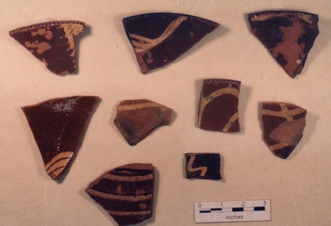
The assemblage of teawares at the Betsey Prince site raises questions about the social and economic status of the household (Figures 7, 8). The teaware collection began as a non-matched set of creamwares, fine red earthenwares, Chinese porcelain, Jackfield, and red stoneware, but a later preference for polychrome pearlwares was demonstrated.[35] By the nineteenth century, tea drinking was a common practice in American households.[36] Tea serving and consumption is associated with domesticity[37], and it can be representative of social interactions.[38]

Figures 7 and 8: A collection of ceramics from the Betsey Prince site, some of which are teawares. Courtesy of the New York State Museum.
One scholar notes the use of medicinal teas by root doctors, midwives, and healers, “brewed from medicinal herbs or substances, salves, or whiskey-based ‘home made bitters’.”[39] Tea cups, tea bowls, and other teawares were also used by African American spiritual leaders as vessels for conjure.[40] Women in colonial New England were recognized for their knowledge of roots and herbal remedies.[41] Perhaps knowledge of healing practices and recipes were shared among people of African, indigenous, and even European descent. If the teawares were used for a purpose other than traditional English tea drinking, then the influence of African, European, and indigenous healing practices may have been demonstrated in the alternative uses of these items.
The teawares could also demonstrate social interaction or social connectedness, and thus serve to identify a point of social congregation. This type of activity was observed through the recovery of matched tea sets at the Harriet Tubman home in Auburn, New York, where Tubman established a home for the aged and served others.[42]
Is the predominance of teawares at the site suggestive of Betsey Jessup’s activities? Could these items be viewed as representative of gendered activities? Some scholars have warned against the association of specific items with certain genders. This trend of identifying separate “spheres of activities” is essentialist and as problematic as trying to identify ethnic markers.[43] However, multiple lines of evidence can provide a better foundation for understanding gendered activities. In the case of the Betsey Prince site, this can be accomplished by comparing the probate inventory with the archaeological record.
The probate inventory enumerated additional material that is indicative of household activities, including a hand saw, square, four chisels, a drawing knife, five axes, a grindstone, a pounding barrel, and a ladder. Similar items recovered during excavations include a horse shoe, a horse shoe nail, a whetstone, and five chisel fragments. In the late eighteenth and early nineteenth centuries people of color in rural Long Island performed various skilled and unskilled tasks for a living.[44] The cutting of cordwood was a common practice in the wooded interior portions of Brookhaven Town, and the material represented in Jessup’s probate inventory suggests he may have engaged in this type of labor. In addition, the four or more chisels, drawing knife, and grindstone/whetstone mentioned in the archival and archaeological records suggest skilled woodworking was an activity performed at the Jessup household or by its members.
An interesting aspect of the probate inventory is the paucity of ceramic and glass items appraised. Four bottles, two stone jugs, one jug, and a two gallon stone jug are the only vessels listed for the storage or preparation of food and/or beverage. This presents a different image of household items than what was recovered during archaeological investigation. As with most documents, the probate inventory provides insight into what was valuable to the appraisers, and may not necessarily reflect what was valued by the owner. However, it is interesting that the extensive collection of teawares was not appraised. If Betsey Jessup owned the ceramic and glass items, then it is possible that her property was excluded from the appraisal. Perhaps the appraisers distinguished between his and her property, or perhaps the appraisers did not assess the ceramic and glass wares as valuable items. Alternatively, the presentation of the estate to the appraisers may not have included the ceramic and glass items. Betsey may have kept these items concealed when her husband’s estate was appraised. It is also possible that she acquired her collection of teawares after her husband’s death. Many of the wares, however, would have been out of date by then. There is a range of factors that contribute to the presence or absence of items in probate inventories, but with the archaeological record, it is incredibly useful for understanding the material assemblage with greater accuracy.
The comparison between the documentary and archaeological records provides subtle hints into the gendered activities at the Betsey Prince site. This is particularly useful at a site such as this one, comprised of a small space that was shared by a husband, wife, and several other individuals. But what is the purpose of separating male from female activities? This analysis is only useful when it is understood within its socio-historical context. Political, economic, racial, ethnic, and class conditions also shape each person’s experiences and lifeways, in the past and in the present. These factors should be considered in an attempt at understanding gendered lifeways at an archaeological site. After all, it is not the artifacts that define a person’s identity in the past, but rather the political, economic, and social experiences that impact a person’s identity. As such, the artifacts must be understood simply as the material residue of social experience.
The “Search” for an African American Archaeological Context
Several categories of material culture have become associated with African American archaeological sites. These items – including blue beads, modified pieces of ceramics, and cowrie shells, to name a few – have been found on free and enslaved sites throughout the Americas, and these items have been regarded by many as representative of an African presence.[45] These artifacts are significant within the context of an archaeological site, but the search for these items is essentialist if they are considered apart from each other, or separate from their placement within the site. When found in specific contexts, these items demonstrate African American meaning. Often identified in caches or bundles, these items have been found in hidden locations of African American homes or workplaces, such as within walls, hidden beneath floor boards, within root cellars, in hearths, below doorways and windows, and in room corners.[46]
Caches or bundles have been found on African American sites containing items such as “crystals, pebbles, gnarled roots, pieces of iron, metal, ivory, wooden rings, and crab claws, usually wrapped in leaves or a cloth.”[47] From an assortment of narratives collected by the Works Progress Administration (WPA) that discuss conjuring, healing, and divining, two scholars have identified “pins, nails, buttons, beads, coins, white ceramics, crystals, jewelry, stones, cloth, and their contexts” as the material evidence of these activities.[48] Not all of these items are found, and some caches contain previously unmentioned artifacts. The diversity of items recovered from similar spiritual and/or healing bundles in various locations may be reflective of the diversity of resources available, ingenuity, the particularity of the conjuring or healing activity, and the heterogeneity of African American people.
Working with the field notes, photographs, and artifacts from the Betsey Prince site, the author investigated the possibilities of identifying potential caches at the site. This research was conducted between 2006 and 2008, more than ten years following the excavation of the site.[49] Locations have been identified in African American houses as sensitive zones for potentially identifying African American caches or bundles.[50] The excavation field notes and artifact catalog for the Betsey Prince site were consulted to explore the conditions of these locations, where possible, and the potential to interpret the data as reminiscent of archaeological material recovered from other known African American contexts. Unfortunately, the locations of windows and doors could not be identified at the Betsey Prince site. However, the chimney base/sill, cellar floor, and cellar storage pit were all thoroughly investigated by the NYSM, and the data was subsequently explored for possible caches.[51] One context seems similar to caches found in sub-floor pits at slave houses in Virginia, but problems with chronological comparisons and clear contexts of intentional placement makes these resemblances tentative at best.[52]
The search for Africanisms in African American culture is a politically charged process of attempting to identify authenticity. In his study of black music, Paul Gilroy makes the point of distinguishing the challenges of two main approaches to interpreting identity formation within the African diaspora: the essentialist approach of ethnic absolutism inherent in Africentrism and its pluralist critique.[53] Residing at an intermediary position within this debate, he argues that “the unabashedly hybrid character of …black Atlantic cultures continually confounds any simplistic (essentialist or anti-essentialist) understanding of the relationship between racial identity and racial non-identity, between folk cultural ethnicity and pop cultural betrayal.”[54] Without denying the importance of African symbols and meaning to the formation of black Atlantic identities and cultures, Gilroy argues that the complex experiences of movement and culture contact have contributed to a hybrid Atlantic identity that emphasizes agency in the selection of cultural features.
Theresa Singleton provides a review of the debates surrounding the interpretation of African American culture in anthropology and archaeology. She notes that although the identification of ethnic markers may provide an initial reference point, “all too often these artifacts become the primary focus of the archaeological discussion, and the interpretation of other objects is not given much consideration.”[55] As an alternative, she suggests that researchers explore the possibilities wherein artifacts and practices may have acquired new meaning, as in appropriation.
The concept of ethnogenic bricolage presents a useful theoretical framework for understanding the processes of identity formation and the creation of an African American culture.[56] This framework emphasizes hybridity, as well as multiple uses or meanings for artifacts, as they may be demonstrated archaeologically. For instance, an English teaware recovered from an African American or Native American context may have been traditionally interpreted as a sign of acculturation. But the item may have had other meanings or uses in different contexts or to different people. It is therefore important to consider the dynamic formation of culture and the various ways to demonstrate tradition, resistance, and appropriation materially.
Unlike acculturation and creolization studies, which are dependent on the recognition of an imbalance of power, this concept of ethnogenic bricolage emphasizes agency within a dynamic culture. Christopher Fennell states that “in a process of ethnogenic bricolage, individuals of different cultural heritages interact over time to formulate new social networks with new repertoires of key symbols, communicative domains, and cultural practices. Those new symbols are created and developed over time in large part through engagements with the multiple elements of abbreviated, multivalent symbols from each of the contributing cultural groups.” [57] This method attempts to understand why certain cultural traits are selected for in the creation of the new blended culture. Its usefulness in accomplishing this fate, however, is yet to be determined.
Perhaps the hybrid composition of early America, which was marked by power shifts and struggle, is best understood as a location of dynamic and contested cultural production. It is likely that the members of the indigenous, African, and Euro-American populations on Long Island, consciously or unconsciously, participated in the formation of a blended culture. By exploring the alternative explanations for the uses of the teawares at the Betsey Prince site, this analysis has investigated hybridity and multiple meanings archaeologically.
Into the Twentieth Century: What Happened to the Betsey Prince Site?
Federal census data, historic maps, and property deeds are useful for reconstructing the demographic changes that occurred in the black neighborhood at Rocky Point in the late nineteenth and early twentieth centuries. Although the black neighborhood at Rocky Point remained small for a short time after Elizabeth Jessup and Jonah Miller died, the residents disappeared from the area by 1920. Meanwhile, black settlements were growing in other parts of northern Brookhaven Town.
The 1830 Federal census, the last census to identify Betty Prince as a head of household, lists her household alongside the households of Benjamin Davis and Jonah Miller. Jonah Miller died before the 1840 census, leaving Benjamin Davis, James Day, and nearby Lydia Phillips documented in the neighborhood. At this time Elizabeth Jessup may have lived with James Day, a seaman whose household included one woman between the ages of 55-100, according to the 1840 census.
Although the Betsey Prince site was abandoned by 1840, the African American community continued. Over the next 80 years, a small number of African American households made the Rocky Point area their home, including the households of David Smith, Abraham Tobias, Theodore Tredwell, James Douglass, and William White.[58] Benjamin Davis lived in his home until he died (approximately 1875). As late as the 1870 census, he was listed as a 90-year-old laborer.
In 1848, Setauket’s Bethel AME Church was founded approximately 12 miles to the west. For Setauket “the church was the religious and educational center for the black community.”[59] Black people lived in Setauket since the English settled in the area. As early as 1815 the Laurel Hill Cemetery was established on Christian Avenue for people of color to bury their dead. The beginnings of the black church and community can be traced at least to that time.[60] The establishment of a church is considered central to the construction of community identity, and served to represent the freedom of Africans in the nineteenth century. Indeed throughout Long Island, African American settlements were often located geographically around an African Methodist Episcopal, AME Zion, or Baptist Church.[61]
Many current black residents of Setauket can trace their ancestry to the earliest black people who made the area their home. Hart, Sells, Tobias, Brewster and Smith are among the oldest names for Brookhaven Town’s, and especially Setauket’s black families. Theodore Green is one such Setauket man who could trace his ancestry to Titus Sells, Rachel Holland Hart, and Abraham Jones Tobias.[62] For members of Green’s family and the extended community, family histories maintain that their ancestors were of African and Native American descent. Free and enslaved Africans intermarried with Setauket, Shinnecock and Montaukett Indians. For these families, and many other black Long Islanders, their identities comprise African, indigenous, and even European heritages.
By the late nineteenth century, many southern African Americans had migrated to New York City[63], and by the early twentieth century, there was a growing population of southern African Americans in eastern Long Island. Like Africans and African Americans before them, these individuals migrated north in search of employment and better opportunities for themselves and their families. Southern black people migrated to Long Island and lived and worked alongside the descendants of the earliest African inhabitants (enslaved and free). Many attended the churches and joined the organizations that were previously established by Long Island African Americans in the nineteenth century. New churches and organizations were established as small groups of African-Americans settled throughout eastern Long Island.[64]
The 1900 Federal census indicates an influx of German-born residents to the Rocky Point area, and most of these immigrants settled on North Country Road where the early-nineteenth-century black residents had lived. By this time, only one black resident remained in the area, James Douglass, who probably resided in the Benjamin Davis/Theodore Tredwell house. The census suggests Douglass, a 70-year-old woodcutter, lived there alone, although he was married for 25 years.
James Douglass is replaced by William White in the 1910 Federal census. White, a 39 year old laborer of “odd jobs” lived with his wife Molly, four children, and mother Ansaline Brewster (74 years old). Identified as mulatto, this is the last household of color identified prior to the significant development changes to Rocky Point that would erase the memories of the black neighborhood.
By 1920, the area was primarily inhabited by German immigrants. No black or mulatto people are listed in the 1920 census or identified on a 1917 map in this area. [65] According to the Federal census, William H. White and his family moved to Crystal Brook Hollow Road in Mount Sinai, west of Rocky Point. It is around this time that real estate companies, such as the Chauncey Real Estate Company, began to buy vast pieces of land along North Country Road in Rocky Point precisely where the eighteenth- and nineteenth-century free black people settled. These parcels were then sold to the Radio Corporation of America.[66] Some of these deeds hint at the early-nineteenth-century presence as they mention Jonah Road as a boundary marker[67], or the Betsey Prince site as property belonging to the “heirs of Elizabeth Jessup.”[68] The rural landscape of Rocky Point made it an ideal setting for the Radio Corporation of America’s installation of a field of towers over 6,200 acres.
For African Americans, life on Long Island during the twentieth century was constantly impacted by racism. In the 1910s and 1920s, the Ku Klux Klan was revived and active throughout Long Island.[69] In Suffolk County, membership was high, and the organization was pervasive in churches, civic organizations, and politics.[70] The political strength of the Klan has been demonstrated in patterns of community segregation, and exclusionary housing practices continued through the middle of the twentieth century. Organized efforts, aimed at “preserving existing housing patterns,” were instituted in suburban models (e.g., Levittown) and red-lining practices (i.e., limited financing to non-white homeowners).[71] African American Long Islanders had limited residential options during this period. They purchased land where permitted and established cohesive communities, some of which remain today.
For Long Island, and other parts of the American northeast, historians and archaeologists alike are exploring the histories of people of color in the colonial and early historic periods.[72] Historical archaeology is uniquely positioned to contribute to this research, to create a more complete image of the past. It may supplement the historical record, or it may challenge it. In many cases, historical archaeologists are interested in illuminating the histories of people who have been identified by Eric Wolf as “without” history.[73] Through the investigation of archaeological remains, documents, and oral testimony, archaeologists can produce a narrative of lifeways at a site that may not have been achieved from the use of just one line of evidence.
For the Betsey Prince site, historical archaeology presents a more complete history of the site, and positions that site within the larger history of Rocky Point. Although the African American history of Rocky Point remains buried in the landscape, an investigation into archived documents, Federal census data, and archaeology has provided the basis for understanding the material dimensions of the site’s inhabitants. Prince Jessup, who lived at the site, was a farmer and/or laborer who died around 1815. The probate inventory from his estate indicated that he owned a collection of tools for woodworking and farming, furniture, domestic items, and farm animals. The archaeological record, however, presented evidence of an affinity for teawares, which were noticeably absent from the probate inventory. Together, these resources provide a more complete picture of the assemblage at the Betsey Prince site, and are suggestive of gendered activities.
The documentary record provided the evidence for identifying the occupants of the Betsey Prince site as black, and for establishing the social, historical, and political conditions of the time. With this context secured, there was little need to “authenticate” the site as African American archaeologically. An African American archaeological context was explored, and possibilities for distinctly African American material culture were identified, but problems with chronology and the identification of intentional placement makes comparisons between this and other sites tentative. In future work at African American archaeological sites, special attention should be paid to sensitive zones within structures during excavation to determine intentional placement.
Archived documents and Federal census data were also used to understand settlement patterning, household composition, and demographics within and around the historic black enclave in Rocky Point. The archaeological record indicates abandonment of the Betsey Prince site by the mid-nineteenth century, and the documentary record is useful in exploring why the site and the black settlement disappeared, providing the evidence for changes in demographics, settlement patterns, and land use into the twentieth century.
On Long Island, as in other parts of the country, current demographics, settlement patterns, and levels of wealth can be understood as the product of history. As such, historical archaeology will play an important role in expanding our knowledge of these processes, while highlighting culture contact, African American history, and the creation of early American societies.
Acknowledgements
Many thanks are owed to Mark LoRusso and Andrea Lain at the New York State Museum. Mark LoRusso was the Principal Investigator of the site in the 1990s and graciously shared his notes and memories of the excavations. Andrea Lain facilitated access to the collections for my master’s thesis research.
Notes
[1] Mark LoRusso, A Cultural Resource Survey Report for Data Recovery Investigations of the Betsey Prince Site (NYSM #10625) and the Prince-Miller Site (NYSM #10626) PIN 0327.67.121 and PIN 0327.78.101, NY 25A, Town of Brookhaven, Suffolk County, New York for the New York State Department of Transportation (Anthropological Survey, New York State Museum, 1998); Mark LoRusso, “The Betsey Prince Site: An Early Free Black Domestic Site on Long Island,” in Nineteenth- and Early Twentieth-Century Domestic Site Archaeology in New York State (New York State Museum Bulletin 495, 2000), 195.
[2] LoRusso, “The Betsey Prince site,” 199.
[3] Allison Manfra, “Race and Ethnicity in Early America Reflected through Evidence from the Betsey Prince Archaeological Site, Long Island, New York” (master’s paper, Syracuse University, 2008); U.S. Bureau of the Census, Population Schedules, 1790-1850; Land deeds (Suffolk County Clerk, Suffolk County Center, Riverhead, New York [SCC] 1818: Deed Liber [DL]84:858, 1833:DL S:265); Brookhaven Tax Receipt for Prince (William Floyd Estate, Mastic, New York, 1815); Probate Inventory for the Prince Jessup Estate (Surrogate’s Court, Suffolk County Center, Riverhead, New York, 1816: Liber D:97).
[4] Manfra, 19.
[5] LoRusso, “The Betsey Prince site,” 195.
[6] Ira Berlin and Leslie M. Harris, Slavery in New York (New York, NY: Plenum Press, 2005), 16-17; Graham Russell Hodges, Root and Branch: African Americans in New York and East Jersey, 1613-1863 (Chapel Hill, NC: University of North Carolina, 1999), 25; Edna Greene Medford, The New York African Burial History Final Report, prepared by Howard University for the General Services Administration Northeastern and Caribbean Region, November 2004, 209-210.
[7] Manfra, 25.
[8] James Oliver Horton, Free People of Color: Inside the African American Community (Washington, DC: Smithsonian Institution Press, 1993), 155.
[9] Peter Ross, A History of Long Island from the Earliest Settlement to the Present Time (New York, NY: Lewis Publishing, 1902), 121.
[10] Helen Wortis, “Blacks on Long Island: Population Growth in the Colonial Period,” Journal of Long Island History 9 (1974); Richard Shannon Moss, Slavery on Long Island: a Study in Local Institutional and Early African-American Communal Life (New York, NY: Garland Publishing, 1993); Lynda R. Day, Making a Way to Freedom: A History of African-Americans on Long Island (Interlaken, NY: Empire State Books, 1997).
[11] Medford, 60-61.
[12] Ibid., 90-93.
[13] Ibid., 83-89.
[14] Day, 89-91; John Strong, The Algonquin Peoples of Long Island from Earliest Times to 1700 (Interlaken, NY: Empire State Books, 1997), 281-282; Theodore Green, personal communication, ca. 2006.
[15] Anne Hartell, “Slavery on Long Island,” Nassau County Historical Journal (Fall 1943): 56; Grania Bolton Marcus, “Discovering the African American Experience on Long Island,” in Exploring African-American History on Long Island and Beyond (Hempstead, NY: Long Island Studies Institute, 1995).
[16] James Moore, “Slavery in the 18th century New York Hinterland: the Spatial Dimension.” Paper presented at the 38th Annual Conference on Historical and Underwater Archaeology, York, England, January 2005.
[17] Ibid.
[18] Robert K. Fitts, “The Landscapes of Northern Bondage,” Historical Archaeology 30, No. 2 (1996): 54.
[19] Records of the Town of Brookhaven, Suffolk County, New York (Port Jefferson, NY: Times Steam Job, 1888).
[20] Mildred H. Gillie, Kate W. Strong, Margaret S. Davis, and Osborn Shaw, Historical Sketches of Settlements and Villages of Northern Brookhaven Town, 1655-1955 (Bellport, NY: U. S. Press, 1955); Dagmar von Bernewitz, Rocky Point: A Historical Perspective, (Long Island, NY: Dag and Rob, 1997).
[21] Nineteenth-century settlement patterns can be seen on the following maps: F. H. Gerdes, North Side of Long Island from Mount Misery to Friar’s Head (United States Coastal and Geodetic Survey, Washington, DC: 1838); J. Chace, Map of Suffolk County, Long Island, New York (John Duglas, Pennsylvania: 1858); F. W. Beers, Atlas of Long Island, New York (F. W. Beers, Comstock, and Cline, New York: 1873).
[22] LoRusso, “The Betsey Prince site,” 199.
[23] Manfra 9, 18.
[24] Records of the Town of Brookhaven, 150.
[25] The Mount Sinai Congregational Church was established in 1789.
[26] Sarah and Jonah Miller, Mineus Lyman, and Betty Sells are listed as members of the Mount Sinai Congregational Church, (Mount Sinai Congregational Church membership records, Mount Sinai Congregational Church, Mount Sinai, New York); account books list consumption and exchanges in Suffolk County (Suffolk County Historical Society, Riverhead, New York); Titus Sells and Black Benjamin were the parents of children enrolled in Miller Place Schools, c. 1830 (U.S. Bureau of the Census, Population Schedules, 1830). Some of these references are discussed in Manfra 2008, and some were reprinted in Grania Bolton Marcus’s Discovering the African-American Experience in Suffolk County, 1620-1860 (Mattituck, NY: Amereon House, 1995[1988]).
[27] Calendar of Historical Manuscripts in the Office of the Secretary of State,
Albany, New York (Ridgewood, NJ: Gregg Press, 1968 [1868]).
[28] Records of the Town of Brookhaven, Suffolk County, New York, Book C (New York, NY: Derrydale Press, 1931), 43; Brookhaven Assessment List, 1799, Suffolk County Historical Society, Riverhead, New York; Brookhaven Tax List, 1810, Suffolk County Historical Society, Riverhead, New York.
[29] LoRusso, A Cultural Resources Survey, 70.
[30] The archaeological data from the Betsey Prince site was re-examined for a 2008 MA paper in Historical Archaeology at Syracuse University. Further archival research was conducted for this project, and during the process, the site was identified as occupied by Prince and Elizabeth Jessup. Allison Joyce Manfra, “Race and Ethnicity in Early America Reflected through Evidence from the Betsey Prince Archaeological Site, Long Island, New York” (master’s paper, Syracuse University, 2008).
[31] Brookhaven Tax Assessment, 1815, William Floyd Estate, Mastic, New York.
[32] Deborah L. Rotman, “Introduction: Exploring Shared Spaces and Divided Places on the American Historical Landscape,” in Shared Spaces and Divided Places: Material Dimensions of Gender Relations and the American Historical Landscape, (Knoxville, TN: The University of Tennessee Press, 2003), 3.
[33] James Delle, An Archaeology of Social Space: Analyzing Coffee Plantations in Jamaica’s Blue Ridge Mountains, (New York, NY: Plenum Press, 1998), 14, quoted in Rotman, 4.
[34] LoRusso, A Cultural Resources Survey, 43.
[35] LoRusso, A Cultural Resources Survey, 78.
[36] Rodris Roth, “Tea-drinking in Eighteenth Century America: Its Ettiquette and Equipage,” in Material Life in America, 1600-1860 (Boston, MA: Northeastern University Press, 1988).
[37] Diana diZerega Wall, “Family Meals and Evening Parties: Constructing Domesticity in Nineteenth-Century Middle-Class New York,” in Lines That Divide: Historical Archaeologies of Race, Class, and Gender (Knoxville, TN: University of Tennessee Press, 2000).
[38] Douglas Armstrong, personal communication, 2008.
[39] Laurie A. Wilkie, “Secret and Sacred: Contextualizing the Artifacts of African American Magic and Religion,” Historical Archaeology 31, no. 4 (1997), 85.
[40] Newbell Niles Puckett, Folk Beliefs of the Southern Negro (Patterson Smith, Montclair, NJ: Patterson Smith, 1968 [1926]); Wilkie, 85.
[41] Jane C. Beck, “Traditional Folk Medicine in Vermont,” Annual Proceedings of the Dublin Seminar for New England Folklife 15 (1992), 39.
[42] Douglas Armstrong, personal communication, 2008.
[43] Elizabeth Brumfiel, “Methods in Feminist and Gender Archaeology: A Feeling for Difference– and Likeness,” in Handbook of Gender in Archaeology (Oxford, MA: AltaMira Press, 2006), 42.
[44] Moss, xiv.
[45] Mark P. Leone, Cheryl Janifer LaRoche, and Jennifer J. Babiarz, “The Archaeology of Black Americans in Recent Times,” Annual Review of Anthropology 34, 582; for a review of African American archaeology, see Charles E. Orser, “Archaeology of the African Diapora,” Annual Review of Anthropology 27, 63-82 and Theresa Singleton, “Archaeology of Slavery in North America,” Annual Review of Anthropology 24, 119-40.
[46] Mark P. Leone and Gladys-Marie Fry, “1999 Conjuring in the Big House Kitchen: An Interpretation of African American Belief Systems Based on the Uses of Archaeology and Folklore Sources,” Journal of American Folklore 112, no. 445 (1999), 372-403.
[47] Leone and Fry, 379.
[48] Leone and Fry, 382.
[49] Manfra.
[50] Leone and Fry, 376-377.
[51] Manfra, 64-65, 68-73.
[52] Ibid., 72-73, 82.
[53] Paul Gilroy, The Black Atlantic: Modernity and Double Consciousness (Cambridge, MA: Harvard University, 1993).
[54] Gilroy, 99.
[55] Theresa A. Singleton, “African Diaspora Archaeology in Dialogue,” in Afro-Atlantic Dialogues:Anthropology in the Diaspora (Santa Fe, NM: School of American Research Press, 2006), 262.
[56] Christopher C. Fennell, Crossroads and Cosmologies: Diasporas and Ethnogenesis in the New World (Gainesville, FL: University Press of Florida, 2007).
[57] Fennell, 129-30.
[58] United States Census Bureau population schedules for 1850-80, 1900, 1910.
[59] Theodore A. Green, “The Hart-Sells Connection,” in William Sydney Mount: Family, Friends, and Ideas: Essays by Members of the William Sydney Mount Project, Three Village Historical Society (Setauket, NY: Three Village Historical Society, 1999), 67.
[60] Marcus, 178.
[61] Day, 54.
[62] Theodore Green, personal communication, ca. 2006.
[63] Ralph Watkins, “A Survey of the African American Presence in the History of the Downstate New York Area,” in Afro-Americans in New York Life and History 15, no. 1 (1991), 53-79.
[64] Day, 109.
[65] E. Belcher Hyde, Atlas of a Part of Suffolk County, Long Island, New York: North Side- Sound Shore (Brooklyn, NY: E. Belcher Hyde, 1917).
[66] Natalie Aurucci Stiefel, Looking Back at Rocky Point: In the Shadow of the Radio Towers, Volume 1- 20th Century (Rocky Point NY: Amron Copy and Printing Center, 2003).
[67] Property deed, SCC 1898: DL 566:468.
[68] Property deed, SCC 1912: DL 829:153.
[69] Steve Wick, Heaven and Earth: the Last Farmers of the North Fork (New York, NY: St. Martin’s Press, 1996), 90.
[70] Wick, 90; Jane S. Gombieski; “Klokards, Kleagles, Kludds, and Kluxers: The Ku Klux Klan in Suffolk County, 1915-1928, Part One.” Long Island Historical Journal 6, no. 1 (1993), 41-62.
[71] Bernie Bookbinder, Long Island: People and Places, Past and Present (New York, NY: Harry N. Abrams, 1998)192; The Klan’s role in community segregation in Freeport is mentioned in Rosalynd Baxtall and Elizabeth Ewen’s Picture Windows (New York, NY: Basic Books, 2000) 30.
[72] About 10 years of multidisciplinary research was conducted at the archaeological site of Sylvester Manor on Shelter Island, adding to our knowledge of culture contact and labor on a northern plantation. The results were published in The Historical Archaeology of Sylvester Manor, a special issue of Northeast Historical Archaeology 36 (2007). More recent research by the Hofstra University’s Center for Public Archaeology at King Manor in Queens and Lloyd Manor in Lloyd Harbor will also add to our understanding of labor and culture contact in New York.
[73] Eric R. Wolf, Europe and the People Without History (Berkeley, CA: University of California Press, 1997[1982]).