While travelling along Middle Road in Cutchogue, New York, you may notice the large Town of Southold sanitation facility seemingly out-of-place among the agricultural fields, vineyards, and farm houses. What you will likely not see is the historic Church Lane neighborhood, which borders the sanitation facility on the north side of Middle Road. This is unfortunate, because this modest African American neighborhood has a significant history that links American migration stories to the changing economics and labor patterns of Long Island’s East End at the turn of the twentieth century. Centered around the First Baptist Church of Cutchogue, the Church Lane neighborhood was established by African American migrants from the American South who sought new economic opportunities in the North in the first half of the twentieth century. The current residents of the neighborhood are connected, through both genealogy and a sense of community, to the founders of the Church and the settlement. The community has an undeniable historical significance, as it links the past with the present. And yet, its very existence was threatened near the end of the twentieth century by a change in local zoning (Figures 1-3).

Figure 1: Map of Long Island showing locations mentioned in text.

Figure 2: United States Geological Survey Maps (Mattituck Hills, Southold, Southampton, Mattituck Hills quads), 1991 New York State Department of Transportation versions, 1:24,000 scale.
In 2002, the residents of the Church Lane neighborhood learned that their properties had been rezoned by the Town Board in 1989 from residential to light industrial without their knowledge, let alone input. This rezoning came to light when members of the community challenged a proposal to build a 5,000 square-foot pool supply warehouse nearby. Church Lane residents arrived at Town Hall to declare their opposition to the proposed development, only to learn that, unbeknownst to them, their residential properties had been rezoned more than a decade earlier. Responding to complaints from the residents that this constituted a form of environmental racism, Joshua Horton, the Southold Town Supervisor at the time, requested that the Town Board reassess its decision. This was no simple task. Indeed, a conflict developed putting Horton and the Church Lane residents at odds with other residents of the Town, who argued that the light-industry zoning enhanced the value of their properties. Despite this opposition, Horton convinced the Town Board to undertake an environmental review of the Church Lane neighborhood and surrounding environs in order to determine the appropriate zoning for the area.[1]

Figure 3: The Church Lane neighborhood. New York State GIS Clearinghouse Division of Homeland Security and Emergency Services,
https://gis.ny.gov/
The research summarized in this paper results from the investigations (written and oral history) conducted by the Institute for Long Island Archaeology (ILIA) at Stony Brook University, as part of this environmental review process. This work has illuminated the racialized past of eastern Long Island, which the rezoning of the Church Lane neighborhood clearly continued. The study was undertaken as part of a larger Neighborhood Plan prepared by the firm of Greenman-Pedersen, Inc., an engineering and land use consulting company, for the Town of Southold. The challenges faced by this small, historically African American community are not unique to Long Island, but the success of this investigation—which empowered residents to deploy the settlement’s history in its own defense—is a testament to its perseverance.[2]
Methodology
For decades, the Institute for Long Island Archaeology (ILIA) at Stony Brook University has performed archaeological and historical studies in advance of development projects. These efforts, generally referred to as cultural resource management projects, are designed to ensure that important historical and archaeological sites (e.g., prehistoric Native American settlements, historic buildings, cemeteries, battlefields, etc.) are not destroyed by construction activities. In 2003, ILIA was given the opportunity to assist the Church Lane community, not in saving a prized monument or historic structure, but in protecting their neighborhood from the impact of rezoning.
This was not the typical project conducted by the Institute for Long Island Archaeology. Most ILIA endeavors involve the archaeological testing of development parcels in search of prehistoric or historic artifacts that are buried below the ground surface. These types of inspections, called archaeological surveys, are mandated by federal, state, and municipal laws that require that surveys be conducted in advance of development projects. Needless to say, this study of the Church Lane neighborhood did not involve the kind of work typically included in an archaeological investigation. However, through its analysis of space and settlement patterns, reliance on historic-period documentation, and incorporation of oral testimonies and residents’ memories, it did, in fact, utilize many kinds of data that are typically used to reconstruct and interpret past landscapes in archaeological research.
The most convincing data for this investigation were obtained from interviews of modern Church Lane residents. The informants shared their documents, genealogical information, and memories of the Church Lane settlement with the ILIA staff. During private interviews, the informants were queried about the origins of their community, the spatial organization and layout of the settlement, and the historical context of the community. Questions were intended to encourage the informants to reflect on how and why the earliest Church Lane residents settled there, and how the neighborhood responded or adapted to economic, political, and cultural changes over time.[3]
Geographical and Historical Setting
The Church Lane neighborhood, comprising slightly less than six acres, is located on the North Fork of eastern Long Island. It is situated north of Middle Road (County Route 48) in Cutchogue, Town of Southold, and includes homes on both sides of Tuthill and Church Lanes (Figure 3). A capped landfill forms the northern boundary of the neighborhood, while Middle Road borders the community on the south. The First Baptist Church of Cutchogue, located near the heart of the Middle Road enclave, has for years served as the community’s center (Figure 4). At the time of this study in 2003, residents of the neighborhood included second and third generation descendants of African American migrant workers (mostly agricultural) who settled there in the 1920s and 1930s. These residents had extensive memories (particularly regarding family histories) of African American life on the east end of Long Island, and of the community that has come to be commonly called Church Lane.

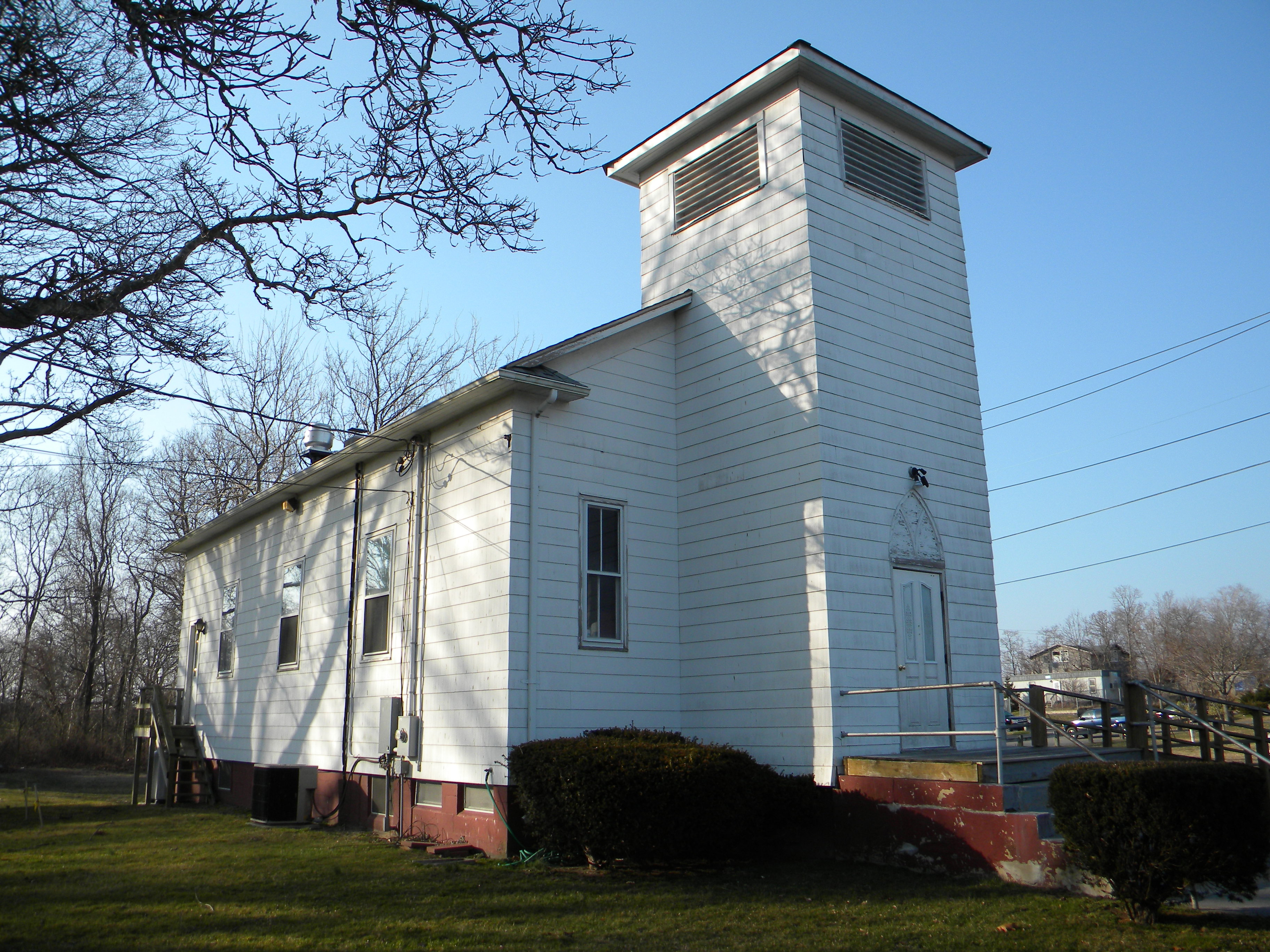
Figure 4: First Baptist Church of Cutchogue in March, 2012. View is north.
The founding residents of Church Lane were not the first African Americans to arrive on the North Fork of eastern Long Island. People of African descent have been residents there since the beginning of colonial settlement in the mid-seventeenth century. However, unlike the European settlers, virtually all of the Africans who arrived in New York and the eastern end of Long Island during this early period were brought here against their will.
Colonial settlers in New York relied on a diverse labor force that was comprised of free and enslaved Africans and Native Americans, as well as indentured Europeans. Slaveholding remained a common practice through the eighteenth century and many Euro-American families on eastern Long Island held small numbers of enslaved laborers to work in their fields and homes. As attitudes about slavery changed in the late eighteenth century, the number of slaves represented in census records decreased. However, African Americans, Native Americans, and poor whites continued to work for more prosperous Euro-American farmers who were descendants of the early European settlers.[4]
The North Fork of eastern Long Island has a long agricultural history that continues to the present day. Farming has been practiced in Cutchogue since the colonial period. Many of the early European proprietors and settlers were farmers in Europe, and they continued in this occupation after their arrival in the Town of Southold, often relying on people of color to labor in their agricultural fields. In 1687, twenty-seven slaves were identified among 113 whites in the Southold census records, “some of whom may have been Corchaugs but the majority of whom were Africans.” These individuals were visible in eastern Long Island society, and many African and Native Americans attended European churches, such as the Cutchogue Presbyterian Church, until the nineteenth century.[5]
Throughout the seventeenth and eighteenth centuries, land was continually cleared for agricultural use in Cutchogue. Goods produced beyond what was needed locally were frequently traded to settlements in Connecticut. The farms that lined Middle Road (Figure 2) near the modern Church Lane community produced large quantities of potatoes, cauliflower, brussel sprouts, strawberries, cranberries, dairy products, and eggs. The Town of Southold remained largely agricultural throughout the nineteenth century and maintains much of its rural character today.[6] With the passage of the Gradual Emancipation Act in 1799, enslaved New Yorkers were manumitted little by little (although some Africans and Native Americans remained legally enslaved in New York until 1827). African Americans founded churches, schools, and other organizations throughout New York, thereby meeting basic social needs and affirming a sense of community. The establishment of a church symbolized freedom and was usually central in the construction of community identity for African Americans in the nineteenth century. Throughout Long Island, African American settlements were often located around an African Methodist Episcopal, AME Zion, or Baptist Church.[7]
Long Island and the Great Migration
By the late nineteenth century, many southern African Americans had migrated to New York City, and by the early twentieth century there was a growing population of southern blacks (especially from Virginia and the Carolinas) on the east end of Long Island. Like other blacks from the American South, these individuals migrated north in search of employment, better opportunities for themselves and their families, and to escape the brutal racism of many (especially rural) southern communities. Although southern African Americans had faced these social and economic hardships since emancipation, it was not until the early twentieth century that they were presented with new possibilities elsewhere. When restrictions were placed on immigration to the United States around World War I, northern employers sought to replace their previous source of cheap labor, namely southern and eastern Europeans, with laborers from the American South. Southern African Americans, particularly tenant farmers who faced replacement by new technologies, could now benefit from the opportunities available in the economic centers of the North. [8] Typically, southern migrants first settled in urban centers, and their northern destinations were often dictated by avenues of transportation. For instance, railways and highways provided connections between Georgia or South Carolina, and Philadelphia, New York, and Boston. In addition, there were other factors that affected migration routes and encouraged chain migrations, including the establishment of community organizations to support newcomers, the availability of employment opportunities, and family connections. On Long Island, for instance, southerners migrated for employment in a variety of fields, including hotel and domestic service at resort locations along the north and south shores, in factories where new industries replaced whaling and maritime commerce, and in agricultural fields, where farmers were experiencing a labor shortage.[9]
During the late nineteenth and early twentieth centuries, southerners journeyed to Long Island’s East End and lived and work alongside the descendants of the earliest African inhabitants of the North Fork. These newcomers often attended the churches and joined the organizations that were previously established by African American Long Islanders in the nineteenth century. In addition, as small enclaves of more recent arrivals settled throughout the East End, they established new churches and organizations.[10]
This migration of southern blacks to the North following World War I is referred to as the Great Migration. Initially, many laborers traveled to the North for seasonal employment, but eventually many of these migrant workers established more permanent homes for themselves and their families on Long Island. Like those before them, twentieth-century African American immigrants created communities that often surrounded a house of worship. The Church Lane neighborhood in Southold is one such community.[11]
Twenty-first century residents of the neighborhood include second and third generation descendants of African American immigrants who settled here in the 1920s and 1930s. Clues to the origins and migration patterns of the early residents of Church Lane can be found by comparing the Federal Census listings for 1930 and 1940. In 1940, the Census listed the names and occupations of all the African American residents (owners and renters) along Tuthill and Church lanes. Some of these same individuals can be identified in the 1930 Federal Census as residents of Virginia or South Carolina prior to migration north.[12]
The earliest migrant laborers probably lived in “tiny shacks or bungalows” on the farms where they were employed. They met for worship in an old building (possibly an old school or church) on Oregon Road and, by 1924, they organized the First Baptist Church of Cutchogue. In 1928, the Church was incorporated, and Reverend E. A. Green, Anderson Cook, John Jacobs, Gilbert Davis, William Brown, and Kelso Cosby were named its trustees. The original congregation continued to worship in the old building on Oregon Road until funds were raised to purchase the present site on Middle Road (Figure 4).[13]
In a deed dated December 15, 1925, five of the six trustees are named in the purchase of a 3.5 acre parcel of land on behalf of the First Baptist Church of Cutchogue. The Church purchased this land from Frank and Anna McBride for $866. As of 2003, the McBride family was still farming north of the Church Lane community near Oregon Road. During the 1920s and 1930s, many of the founders and original congregation members of the First Baptist Church worked on farms owned by the McBride, Glover, Tuthill, and Wickham families. Perhaps the McBrides were more willing than other whites to sell land to people of color; or maybe the land they sold was inauspicious. Regardless of the reason, this location has been historically identified as “the only place in the North Fork town where whites would sell land to blacks.”[14]
In 1929, the Church began to sell portions of its property to congregation members, who in turn, established homes on the land surrounding the First Baptist Church of Cutchogue. Several deeds dating to 1929 and 1930 are evidence of the sale of small portions of church lands to its trustees (including Reverend E. A. Green, Anderson Cook, and others) for the amount of $1.00 each. These were small parcels, measured in mere feet and less than an acre in size, and their sale price likely reflects an attempt to avoid paying a transfer tax. Personal communications with current and former residents of Church Lane indicate that the current properties and homes surrounding the church were inhabited by original congregation members starting around the 1930s. Wyche, Taylor, Ford, Brown, and Mason are the names of some of the original African American residents of the community.[15]
James and Ida Mason, both formerly of Emporia, Virginia, lived in a house behind the church on Tuthill Lane. Bell and George Taylor lived next to Sam and Sue Wyche Brown, also on Tuthill Lane (Figure 3). These parcels were purchased individually from Ralph and Grace B. Sterling and Frank and Anna McBride. At that time, Reverend Green resided in a red house (extant) next to the Church.[16]
Sometime in the 1920s or 1930s Jennie and Nathan Harris (ancestors of some 2003 residents) migrated to the North Fork from Virginia. They purchased land from Mr. Wickham (possibly Tom Wickham’s father), a farmer, and then moved two houses from Mattituck to their newly-acquired property. Nathan Harris worked on Mr. Wickham’s farm. The capped landfill that borders the Church Lane community on the north and west began operation immediately following the infamous hurricane of 1938 (Figure 3). Debris from the clean-up of the destruction caused by the hurricane was disposed of on this parcel, and thereafter it became the main dumping ground for the Town. The residents remained in the Church Lane neighborhood, even as the adjacent landfill grew to encompass its entire northern border.[17]
The community remained predominantly African American throughout the remainder of the twentieth century. Migration of laborers to the North Fork continued during this period (especially between the 1940s and 1960s). Indeed, North Fork farmers encouraged the arrival of migrant laborers in the 1940s. Severe labor shortages resulted from the need for American men to join the military during World War II. North Fork farmers attempted to resolve the labor crisis by encouraging the importation of men from the British island of Jamaica for paid, seasonal work in the fields. The Jamaican workers were desired for their agricultural experience (mainly working on sugar and banana plantations), despite their lack of familiarity with mechanized farm equipment. They earned $24 per week for working six 10-hour days in the fields. Initially, these migrant laborers were housed in a three-story building called Lake Lodge, located on a small lake in Peconic. In order to accommodate this growing migrant population, four migrant camps were subsequently established in Suffolk County. An estimated 10,000 Jamaican volunteers were identified in the United States in 1943.[18]
Around 1944, the Eastern Suffolk Cooperative, Inc. was established to offer support for both farmers and the estimated 3,000 migrant workers that arrived in Suffolk County each season. Labor camps were constructed to provide both housing for migrant workers and their families, and a point of contact for farmers to recruit workers. The Greenpoint Labor Camp was the first labor camp built on the North Fork. Its residents included large numbers of Polish migrant laborers, many of whom were fleeing the oppression resulting from the Nazi occupation of their homelands. Not unexpectedly, many ethnic groups came to be associated with particular areas throughout the North Fork (e.g., the Polish presence at the Greenpoint Labor Camp).[19]
The Cutchogue Labor Camp was formed shortly after the Eastern Suffolk Cooperative, Inc. Cutchogue farmers encouraged migrant laborers to relocate to Cutchogue for employment on farms. The organization purchased land on Cox Lane, and constructed barracks to house migrant workers (mostly African American) from Georgia, Virginia, and the Carolinas. Army surplus barracks and platform tents were constructed, and eventually housed as many as 400 laborers. This was a dusty, street-lined village “fenced from the road with barbed wire, unpainted, close-packed, drab and colorless.”[20]
By 1950, the camp had expanded to resemble a small village complete with showers, a recreation room, and a school for children. Some of the new arrivals during this period eventually moved to the Church Lane neighborhood. Needless to say, living conditions were better there than in the labor camps and farms comprising the so-called “Migrant Alley” of the North Fork.[21] Given Long Island’s diverse labor pool, it is interesting to consider the interactions and relationships that may have occurred between migrant workers of different national, ethnic, and class backgrounds. Members of these different migrant groups undoubtedly came into contact with each other, but little is known at this time about the nature of those interactions.
In the 1960s, the influx of migrant workers to Long Island diminished greatly as the deplorable conditions of the labor camps were exposed to local and national audiences. At the Cutchogue Labor Camp, for example, fires resulting from the illegal use of kerosene stoves took the lives of several men at the camp. Described as one of the worst in Suffolk County, it was featured in Edward R. Murrow’s 1960 documentary about migrant labor entitled Harvest of Shame. Civil rights organizations sought reform of the camps, but eventually the camps were closed as the migrant labor force was replaced with new agricultural machinery.[22]
The Racialization of Church Lane
In 1989, despite the fact that the African American settlement at Church Lane predated the 1938 establishment of the adjacent dump, Town officials rezoned the area for light industrial uses, on the grounds that proximity to the landfill, with its attendant pollution and contaminants, caused the property to be no longer suitable for residential use. Although at the time one newspaper article insisted that the rezoning was not an attempt to displace the Church Lane residents, others (ie., reporters, historians and activists) countered that the rezoning reflected a pattern of environmental racism often used to devalue and displace low-income and/or racially-segregated neighborhoods.[23]
While the heated debate over the rezoning of Church Lane seems on the surface like a minor local controversy, it was highly distressing for those who found their homes and themselves marginalized. Moreover, this case must be contextualized with the significant, larger historical problem on Long Island of (deliberate and de facto) racial discrimination in land use and development. Racially-segregated settlement patterns in the Long Island landscape are deeply-rooted. In the nineteenth century (and earlier), many African American communities on Long Island were organized by working-class individuals who constructed their settlements around community and faith.
Beginning in the late nineteenth and continuing through the early twentieth centuries, however, changing economic patterns, evidenced in the development of new industries, including fuel production and mass-produced commodities, provided new labor opportunities for immigrants to Long Island. This, in turn, resulted in new kinds of land uses that reflected the region’s changing demographics and housing needs. For instance, a period of financial growth in Manhattan led to the development of resort communities on Long Island for middle- and upper-class families. As these neighborhoods of summer homes grew, the demand for service laborers correspondingly also increased. In Nassau County, for example, the community of Freeport had become a popular resort by the early twentieth century. Large hotels and wealthy homes were constructed near the shore, as businessmen, entertainers, and other members of the wealthy elite would vacation there.[24]
By 1910, a wave of migrants arrived, including many African Americans from the American South who came in search of better employment opportunities. They settled near the Long Island Railroad in Bennington Park, a planned community in the Village of Freeport that was originally designed for upper-middle-class vacation homes. (See Figure 1.) Southern-born African Americans lived alongside white immigrants of Italian, Irish, and Eastern European ancestry, finding employment in skilled and unskilled positions, as day laborers, hotel staff, or domestic workers in the homes of elite (mostly white) Long Islanders.[25]
Over the next thirty years, a rapidly-growing working-class of African Americans and whites made Bennington Park their home. Most African Americans worked for the wealthy white elite as laborers, chauffeurs, and housekeepers, but some men also worked in the coal yard, lumber yard, and in skilled trades. By 1950, Bennington Park was crowded and run down. While some African Americans owned their homes in Bennington Park, most rented from landlords who made few improvements to the buildings. The poor living conditions were identified by the New York State Housing Commission and Freeport residents, who sought to redevelop the location. Most of the homes were demolished and the location was rezoned for commercial use as part of a redevelopment plan in the 1950s. The residents of Bennington Park were forced to find homes elsewhere, and some African Americans moved to other sections of Freeport, including the units of low-income housing that were part of the redevelopment plan. Under the rubric of urban renewal, plans for neighborhood redevelopment on Long Island (and elsewhere) have frequently been interpreted as institutionalized displacement of communities of color.
Despite opportunities for economic growth, African Americans throughout Long Island encountered the effects of racism in many organized forms by the turn of the twentieth century. The Ku Klux Klan had an active chapter on the North Fork (and elsewhere on Long Island); some of the local white farmers and businessmen were participants in the activities of this notorious organization. In much of Long Island, twentieth-century housing patterns were dictated by blockbusting, red-lining, and other discriminatory practices. In some areas, urban planning and gentrification also contributed to structural racism that effectively destroyed non-white and/or low-income neighborhoods. Exclusionary housing practices were prevalent and efforts aimed at preserving existing housing patterns of historically white neighborhoods, were instituted. Consequently, many African Americans on Long Island, like the inhabitants of Church Lane, had limited residential options during this period. They bought land where they could, and in the case of Church Lane, were successful in establishing strong, cohesive, and persistent communities.[26] Following the review of two land-use studies in 2003, the Southold town board finally approved a zone change for the Church Lane neighborhood from light industrial back to residential.
Conclusion
The twenty-first century residents of the Church Lane neighborhood faced the possibility of losing their homes when they realized that their properties had been rezoned from residential to light industrial years earlier without their knowledge. While this threat to the community has been compared by one local historian to the destruction of other historically African American settlements, the Church Lane neighborhood fortunately did not face this fate. Whereas the legacy of Bennington Park remains only in the form of photographs and files at the Freeport Historical Society, the Church Lane community endures as a living entity in its original location.[27]
The modern Church Lane neighborhood is directly linked with the original community formed by African American farm workers in the 1920s and 1930s. Descendants of the original settlers still reside in the community or nearby towns, and are employed in a variety of occupations. Many are still active members of the First Baptist Church, a congregation that has grown to include residents of various communities in the Towns of Southold, Riverhead, and Southampton.
Twentieth-century enclaves or neighborhoods of working-class people are rarely documented in any form other than the occasional newspaper article or local history file until they are threatened or lost. Indeed, knowledge of these neighborhoods survives mainly in genealogies, oral histories, and the memories of their residents. For the Church Lane neighborhood, Federal Census records, newspaper clippings documenting key events, and interviews with long-term residents provided the basis for the historical narrative about the motivations, expectations, and patterns of one significant stream of the Great Migration from the rural South to the rural North.[28]
While the history of the Church Lane neighborhood is a fascinating account in its own right, the practical consequences of this research are even more significant. The applied research initiated by the Town of Riverhead and conducted by the staff of the Institute for Long Island Archaeology was instrumental in helping the residents of this historic settlement preserve their traditional community in the face of modern political and economic pressures. By documenting the history, traditions, and cohesion of the Church Lane neighborhood, an adverse zoning decision was over-turned and community residents could feel safe, at least in the short-term, that they would not be displaced and that the buildings and landscape to which they feel such a strong connection will be maintained.
Acknowledgements
The authors would like to thank Christopher Matthews for the invitation to participate in this thematic issue of the LIHJ. We also sincerely thank Mark Tweedie for his assistance with graphics and archival research. Research on the history of the Church Lane neighborhood was greatly assisted by Antonia Booth, the Southold Town Historian; Denise Ross, the Clerk of the First Baptist Church of Cutchogue; and Mariella Ostroski, Local History Librarian at Cutchogue-New Suffolk Library. Most of what was learned of the history of the Church Lane neighborhood during the course of this project was through oral accounts, and we are so grateful to those individuals who generously recounted their family’s histories and their recollections of earlier times on the North Shore of Long Island.
Notes
[1] Bill Bleyer and Mitchell Freedman, “Cutchogue Rezones Neighborhood,” Newsday, October 8, 2003, accessed January 30, 2012, http://www.newsday.com/news/cutchogue-rezones-neighborhood-1.372987?print=true. Lynda R. Day, “Quick, Before It’s Gone: Cutchogue’s Tiny Black Enclave is a Piece of Local History Worth Saving,” Newsday, June 14, 2003; Gary P. Joyce, “The Beginning: A Brief Look at Church Lane’s History,” Traveler Watchman, September 4, 2003.
[2] David J. Bernstein and Allison Manfra, “Church Lane Neighborhood Plan Historical and Cultural Research, Town of Southold, Suffolk County, New York,” (Report on file, The Institute for Long Island Archaeology, Department of Anthropology, Stony Brook University, 2003).
[3] The oral histories collected for this research were recorded in written form and kept on file at the Institute for Long Island Archaeology at Stony Brook University. The interviews are confidential, and not available for public access.
[4] For references on slavery in New York, see Ira Berlin and Leslie M. Harris, Slavery in New York (New York, NY: Plenum Press, 2005); Graham Russell Hodges, Root and Branch: African Americans in New York and East Jersey, 1613-1863 (Chapel Hill, NC: University of North Carolina, 1999); Edna Greene Medford, The New York African Burial History Final Report (Report prepared by Howard University for the General Services Administration Northeastern and Caribbean Region, November 2004). For Long Island slavery, see Allison Manfra McGovern, “Rocky Point’s African American Past: A Forgotten History Remembered Through Archaeology at the Betsey Prince Site,” Long Island Historical Journal 22-1 (2011), accessed March 12, 2012,
http://www.stonybrook.edu/lihj/IssueFiles/V22_1/Articles/Manfra/Manfra.html; Richard Shannon Moss, Slavery on Long Island: A Study in Local Institutional and Early African-American Communal Life (New York, NY: Garland Publishing, 1993); Lynda R. Day, Making a Way to Freedom: A History of African-Americans on Long Island (Interlaken, NY: Empire State Books, 1997); Helen Wortis, “Blacks on Long Island: Population Growth in the Colonial Period,” Journal of Long Island History 9 (1974); Peter Ross, A History of Long Island from the Earliest Settlement to the Present Time (New York, NY: Lewis Publishing, 1902), 121. Anne Hartell, “Slavery on Long Island,” Nassau County Historical Journal (Fall 1943): 56; Grania Bolton Marcus, “Discovering the African American Experience on Long Island,” in Exploring African-American History on Long Island and Beyond, ed. Natalie A. Naylor (Hempstead, NY: Long Island Studies Institute, 1995).
[5] Augustus Griffin, Griffin’s Journal: First Settlers of Southold (New York: Oysterponds Historical Society, 1983 [1857]); Henry Isham Hazelton, The Boroughs of Brooklyn and Queens, Counties of Nassau and Suffolk, Long Island, New York, 1609-1924 (New York: Lewis Historical Publishing Co., Inc); Steve Wick, Heaven and Earth: the Last Farmers of the North Fork (New York: St. Martin’s Press, 1996), 1950.
[6] Richard M. Bayles, Historical and Descriptive Sketches of Suffolk County (Port Jefferson: self published, 1874).
[7] For Gradual Emancipation in New York State, see Berlin and Harris, 16-17; Hodges, 25; Medford, 209-210. For the formation of African American organizations in New York history, see Ira Berlin, “Time, Space, and the Evolution of Afro-American Society on British Mainland North America,” American Historical Review 85:1 (1980): 44-78; Daniel Perlman, “Organization of the Free Negro in New York City, 1800-1860,” Journal of Negro History 56:3 (1971): 181-197; Ralph Watkins, “A Survey of the African American Presence in the History of the Downstate New York Area,” Afro-Americans in New York Life and History 15:1 (1991): 53-79; Corey Dolgon, The End of the Hamptons (New York: NYU, 2005), 157-196; Day 1997, 54.
[8] Watkins, 53-79; Isabel Wilkerson, The Warmth of Other Suns: The Epic Story of America’s Great Migration (New York: Random House, 2010); Stewart E. Tolnay, “The African American ‘Great Migration’ and Beyond,” Annual Review of Sociology 29 (2003): 215; William J. Collins, “When the Tide Turned: Immigration and the Delay of the Great Black Migration,” Journal of Economic History 56(1997): 607-632; James N. Gregory, Southern Diaspora: How the Great Migrations of Black and White Southerners Transformed America (Chapel Hill, NC: University of North Carolina Press, 2005).
[9] Tolnay, 217; Dolgon 166-167.
[10] Day 1997, 109.
[11] Day 1997; Watkins 1991.
[12] United States Census Bureau population schedules for 1930, 1940.
[13] Wick 1990, 11; Antonia Booth, “The First Baptist Church of Cutchogue,” Unpublished Ms., Office of the Southold Town Historian, n.d.; Lucy T. Jenkins, Baptist Church Makes its 25th Anniversary,” Watchman, June 23, 1947; Denise Ross, “Historical Account of the First Baptist Church of Cutchogue,” Unpublished Ms., First Baptist Church Records, n.d; Certificate of Incorporation (Suffolk County Clerk, Suffolk County Center, Riverhead, New York [SCC] Liber 18:341).
[14] Land Deed, SCC 1925: Deed Liber 1164:227; Wick 1996.
[15] Day 2003; Wick 1990; Wick 1996, 91; Land Deed, SCC 1929: Deed Liber 1428:70; 1462:46; 1500:192, 195; Land Deed, SCC 1930: Deed Liber 1546:427.
[16] Land Deed, SCC 1930: Deed Liber 1546:427, 1536:451; Land Deed, SCC 1941: Deed Liber 2264:393; Land Deed, SCC 1944: Deed Liber 2348:176, 178. Oral testimonies.
[17] Bleyer and Freedman 2003.
[18] Antonia Booth, “Labor Camps in Migrant Alley,” Peconic Bay Shopper, 2012, pp. 3-7.
[19] Booth 2012, 3. United States Population Schedules for 1930, 1940.
[20] Booth 2012, 4.
[21] Bill Bleyer, “The Hard Life in Migrant Alley,” Newsday, June 7, 1998, accessed online on July 17, 2003; Wick 1996; “Work Near Completion on Migrant Alley Camp at Cutchogue,” Long Island Traveler, July 11, 1946; Smith 1950.
[22] Cutchogue history file, Cutchogue-New Suffolk Free Library. Edward R. Murrow, Harvest of Shame, Documentary, CBS Reports (1960; New York: CBS).
[23] Bleyer and Freedman 2003; Day 2003; Andrew Wiese, Places of Their Own: African American Suburbanization in the Twentieth Century (Chicago: University of Chicago, 2004).
[24] Dolgon 166-7; Wiese 105.
[25] United States Population Schedules, 1900, 1910; Bennington Park files, Freeport Historical Society.
[26] Wick 1996, 90; Jane S. Gombieski; “Klokards, Kleagles, Kludds, and Kluxers: The Ku Klux Klan in Suffolk County, 1915-1928, Part One.” Long Island Historical Journal 6:1 (1993), 41-62.
[27] Day 2003; Wiese 105-6; Racism and the Opportunity Divide on Long Island, prepared for the ERASE Racism Initiative of the Long Island Community Foundation, July 2002, accessed on September 27, 2012, http://www.racialequitytools.org/resourcefiles/irp.pdf; Rosalyn Baxandall and Elizabeth Ewen, Picture Windows (New York, NY: Basic Books, 2000) 30.
[28] Wilkerson 2010. Paul Richard Thompson, The Voice of the Past: Oral History (Oxford: Oxford University Press, 2000).